IMAGES TAKEN NEAR TO
Dunsford, EXETER, EX6 7BA
Introduction
This page details the photographs taken nearby to EX6 7BA by members of the Geograph project.
The Geograph project started in 2005 with the aim of publishing, organising and preserving representative images for every square kilometre of Great Britain, Ireland and the Isle of Man.

There are currently over 7.5m images from over14,400 individuals and you can help contribute to the project by visiting https://www.geograph.org.uk
Image Map
Images are licensed for reuse under creativecommons.org/licenses/by-sa/2.0
Notes
- Clicking on the map will re-center to the selected point.
- The higher the marker number, the further away the image location is from the centre of the postcode.
Image Listing (9 Images Found)
Images are licensed for reuse under creativecommons.org/licenses/by-sa/2.0
Image
Details
Distance
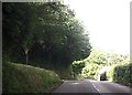
1
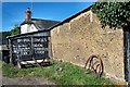
Dunsford Cider farm
A great place to buy real Devon cider, honey and cider vinegar.
Image: © Fiona Avis
Taken: 14 Aug 2005
0.02 miles
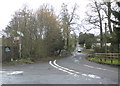
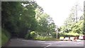
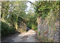
3
Farrant's Bridge
A crossing of the Sowton Brook. The nearby farm is Farrants without an apostrophe, but the OS gives the bridge an apostrophe
Image: © David Smith
Taken: 31 Oct 2014
0.04 miles
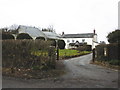
6
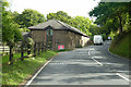
Converted building by B3212
Near Nogsland Farm but the other side of the brook. Probably once a farm building.
Image: © Robin Webster
Taken: 7 Sep 2019
0.07 miles
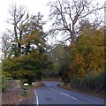
8
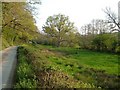
Sowton Brook valley
The lane from Shepherd's Ford runs along the foot of woodland on the valley side. The brook runs past the trees on the right, across a meadow with a prominent oak.
Image: © Derek Harper
Taken: 11 May 2006
0.14 miles
9
Remains of railway bridge, near Britton Brake
Image: © Roger Cornfoot
Taken: 20 May 2010
0.17 miles