IMAGES TAKEN NEAR TO
Dunsford, EXETER, EX6 7AX
Introduction
This page details the photographs taken nearby to EX6 7AX by members of the Geograph project.
The Geograph project started in 2005 with the aim of publishing, organising and preserving representative images for every square kilometre of Great Britain, Ireland and the Isle of Man.

There are currently over 7.5m images from over14,400 individuals and you can help contribute to the project by visiting https://www.geograph.org.uk
Image Map
Images are licensed for reuse under creativecommons.org/licenses/by-sa/2.0
Notes
- Clicking on the map will re-center to the selected point.
- The higher the marker number, the further away the image location is from the centre of the postcode.
Image Listing (7 Images Found)
Images are licensed for reuse under creativecommons.org/licenses/by-sa/2.0
Image
Details
Distance
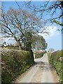
3
Footpath along old track to Shepherd's Ford
Image: © David Smith
Taken: 29 Mar 2019
0.15 miles
4
Field gate used by footpath west of Honeyway
Image: © David Smith
Taken: 29 Mar 2019
0.17 miles
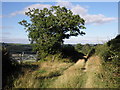
5
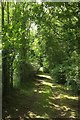
Path to Great Plantation
A lovely shady path leads to the Woodland Trust wood.
Image: © Derek Harper
Taken: 16 Jun 2016
0.20 miles
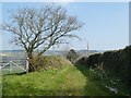
6
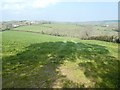
Field and view north of Honeyway
On the left is Serenity Hill with Kelland Farm (to left) and West View Farm (large barn)
Image: © David Smith
Taken: 29 Mar 2019
0.20 miles
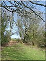
7
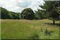
Trees in field by Great Plantation
From the lane south of Kelland Farm. Great Plantation, on the left, is owned by the Woodland Trust. Not that great in size, but it obviously has other merits.
Image: © Derek Harper
Taken: 16 Jun 2016
0.22 miles