IMAGES TAKEN NEAR TO
Drewsteignton, EXETER, EX6 6QR
Introduction
This page details the photographs taken nearby to EX6 6QR by members of the Geograph project.
The Geograph project started in 2005 with the aim of publishing, organising and preserving representative images for every square kilometre of Great Britain, Ireland and the Isle of Man.

There are currently over 7.5m images from over14,400 individuals and you can help contribute to the project by visiting https://www.geograph.org.uk
Image Map
Images are licensed for reuse under creativecommons.org/licenses/by-sa/2.0
Notes
- Clicking on the map will re-center to the selected point.
- The higher the marker number, the further away the image location is from the centre of the postcode.
Image Listing (112 Images Found)
Images are licensed for reuse under creativecommons.org/licenses/by-sa/2.0
Image
Details
Distance
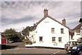
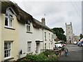
4
Drewsteignton
On the left are the last few buildings in Image The cottages on the immediate left were originally one C17 building, now split into three http://www.imagesofengland.org.uk/Details/Default.aspx?id=94912&mode=adv . Beyond is Image, seen from the other direction http://www.imagesofengland.org.uk/details/default.aspx?id=94913 . Across the square, in which a camper van is parked, is Image
Image: © Derek Harper
Taken: 11 Sep 2009
0.01 miles
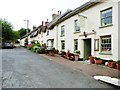
5
Drewsteignton
View from The Old Inn, past the Drewe Arms, towards Holy Trinity Church.
www.drewsteigntonparish.co.uk
Image: © Colin Smith
Taken: 30 Jul 2021
0.02 miles
6

Drewsteignton, 1954
View eastward, to Holy Trinity Church with Drewes Arms Hotel on the left: an identical scene to Image and Image, but about 60 years earlier.
Image: © Ben Brooksbank
Taken: 29 Aug 1954
0.02 miles
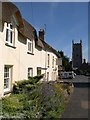
7
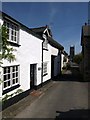
Hillmorhay, Drewsteignton
A pretty street of cottages that leads down to the village square. The cottage on the immediate left seems to be the only one not listed. Next to it is a barn forming part of the thatched C16 Ardonay Cottage http://www.imagesofengland.org.uk/Details/Default.aspx?id=94910&mode=adv . As so often in the village, the tower of Image is prominent in the view.
Image: © Derek Harper
Taken: 11 Sep 2009
0.02 miles
8
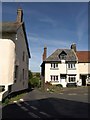
Corner of village square, Drewsteignton
A reverse view of the entrance into the square from the north, the lane (Netherton Hill) to the Fingle Brook valley. Here is how the Conservation Area Appraisal at http://www.dartmoor-npa.gov.uk/drews24-31.pdf describes it: "Pinch point: The entrance to the heart of the village from the north is made especially theatrical by the way in which the lane narrows dramatically and the space is filled by the large 3 storey Victorian edifice at the top. The contradiction of scale is a little confusing and makes the joy of the open square a more remarkable surprise for the visitor. It also acts as an effective ‘informal’ traffic calming measure." On the left is the corner of Image
Image: © Derek Harper
Taken: 11 Sep 2009
0.02 miles
9

Netherton Hill, Drewsteignton
This is the view as you approach Image from the Fingle Brook valley. "The entrance to the heart of the village from the north is made especially theatrical by the way in which the lane narrows dramatically and the space is filled by the large 3 storey Victorian edifice at the top. The contradiction of scale is a little confusing and makes the joy of the open square a more remarkable surprise for the visitor. It also acts as an effective ‘informal’ traffic calming measure. http://www.dartmoor-npa.gov.uk/drews24-31.pdf "
Image: © Derek Harper
Taken: 11 Sep 2009
0.02 miles
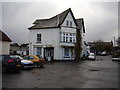
10
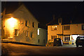
Drewsteignton : Village Road
A road heading through Drewsteignton.
Image: © Lewis Clarke
Taken: 1 Nov 2016
0.02 miles