IMAGES TAKEN NEAR TO
Cheriton Bishop, EXETER, EX6 6HP
Introduction
This page details the photographs taken nearby to EX6 6HP by members of the Geograph project.
The Geograph project started in 2005 with the aim of publishing, organising and preserving representative images for every square kilometre of Great Britain, Ireland and the Isle of Man.

There are currently over 7.5m images from over14,400 individuals and you can help contribute to the project by visiting https://www.geograph.org.uk
Image Map
Images are licensed for reuse under creativecommons.org/licenses/by-sa/2.0
Notes
- Clicking on the map will re-center to the selected point.
- The higher the marker number, the further away the image location is from the centre of the postcode.
Image Listing (8 Images Found)
Images are licensed for reuse under creativecommons.org/licenses/by-sa/2.0
Image
Details
Distance
1

West Ford Farm
Taken from the Two Moors Way.
Image: © Grant Sherman
Taken: 13 Dec 2005
0.05 miles
2
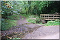
Ford and Footbridge at Ford Cross
This ford is found at the entrance to West Ford Farm. There is another ford on the road adjacent. The Two Moors Way crosses the stream at this ford and also fords streams at Veet Mill Farm (Image) and Low Jurston Farm (Image).
Image: © John Walton
Taken: 24 Sep 2013
0.07 miles
3
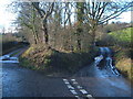
Ford Cross
The two routes rejoin after each fords the River Yeo - the right lane, which is the only trafficworthy one, crosses the river in the dip which is partly visible, though it frankly isn't much of a ford. Cheriton Bishop Footpath 16 follows the track to the left, joining the Two Moors Way. Another track, Ford Lane, leaves this junction to the left.
Image: © Derek Harper
Taken: 2 Dec 2006
0.14 miles
4
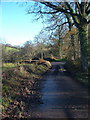
Ford Cross
The reverse view of Image, looking back along the right-hand lane in that photo.
Image: © Derek Harper
Taken: 2 Dec 2006
0.14 miles
5
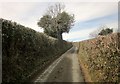
Lane above West Ford Farm
A reverse view of Image with the same tree.
Image: © Derek Harper
Taken: 10 Mar 2015
0.19 miles
6
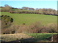
Yeo valley at Thornehill Farm
Looking across the valley from the same point as Image Fields rise towards Hill Farm. The field in the centre is crossed by Hittisleigh Footpath 7 which runs along the valley.
Image: © Derek Harper
Taken: 2 Dec 2006
0.19 miles
7

Lane to West Ford Farm
A lane drops through the corner of this square towards the Yeo valley.
Image: © Derek Harper
Taken: 2 Dec 2006
0.22 miles
8

Yeo valley at Thornehill Farm
Looking down the valley from the steep lane between Ford Cross and Thorne Cross, at the entrance to the farm.
Image: © Derek Harper
Taken: 2 Dec 2006
0.25 miles