IMAGES TAKEN NEAR TO
Tedburn St. Mary, EXETER, EX6 6AJ
Introduction
This page details the photographs taken nearby to EX6 6AJ by members of the Geograph project.
The Geograph project started in 2005 with the aim of publishing, organising and preserving representative images for every square kilometre of Great Britain, Ireland and the Isle of Man.

There are currently over 7.5m images from over14,400 individuals and you can help contribute to the project by visiting https://www.geograph.org.uk
Image Map
Images are licensed for reuse under creativecommons.org/licenses/by-sa/2.0
Notes
- Clicking on the map will re-center to the selected point.
- The higher the marker number, the further away the image location is from the centre of the postcode.
Image Listing (10 Images Found)
Images are licensed for reuse under creativecommons.org/licenses/by-sa/2.0
Image
Details
Distance
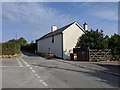
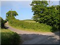
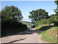
2
Barton Head junction
The road on the left drops steeply towards the A30 and Pathfinder Village. There are a few houses around the junction
Image: © David Smith
Taken: 31 Jul 2012
0.04 miles
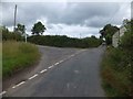
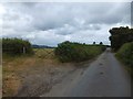
4
Barton Head lane junction between Dunsford and Londown
Image: © Rob Purvis
Taken: 12 Aug 2020
0.04 miles
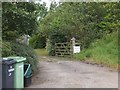
6
Adjacent field gates near Newhouse Farm
Image: © David Smith
Taken: 31 Jul 2012
0.10 miles
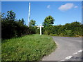
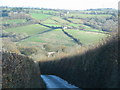
7
Lane to Downhouse Farm
A farm lane leading off from the ridge-top lane between Barton Head and Halstow.
Image: © Derek Harper
Taken: 6 Jun 2006
0.17 miles
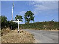
8
Lane drops down the hill from Barton Head Cross
Image: © Sarah Charlesworth
Taken: 25 Nov 2009
0.18 miles
10
Entrance to Babaji Temple at Haccadown
Image: © David Smith
Taken: 31 Jul 2012
0.23 miles