IMAGES TAKEN NEAR TO
Home Close, EXETER, EX5 7HS
Introduction
This page details the photographs taken nearby to Home Close, EX5 7HS by members of the Geograph project.
The Geograph project started in 2005 with the aim of publishing, organising and preserving representative images for every square kilometre of Great Britain, Ireland and the Isle of Man.

There are currently over 7.5m images from over14,400 individuals and you can help contribute to the project by visiting https://www.geograph.org.uk
Image Map
Images are licensed for reuse under creativecommons.org/licenses/by-sa/2.0
Notes
- Clicking on the map will re-center to the selected point.
- The higher the marker number, the further away the image location is from the centre of the postcode.
Image Listing (3 Images Found)
Images are licensed for reuse under creativecommons.org/licenses/by-sa/2.0
Image
Details
Distance
1

Railway line at Crannaford
The Waterloo line from Exeter heads across the East Devon countryside. Here it crosses the Cranny Brook twice; the sinuous course of the stream is shown by the line of trees.
Image: © Derek Harper
Taken: 1 Jul 2009
0.16 miles
2
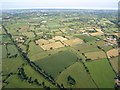
Countryside north of Rockbeare
Taken from a hot air balloon, whose shadow can be seen in the centre of the image near farms at Southbrook. To the left is the railway line to Honiton shown in Image; nearly parallel to it across on the right is the Roman Road past Rockbeare.
Image: © Derek Harper
Taken: 1 Jul 2009
0.17 miles
3
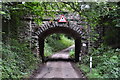
East Devon : Southbrook Lane
Looking along Southbrook Lane as it heads underneath the railway bridge.
Image: © Lewis Clarke
Taken: 4 Aug 2015
0.24 miles