IMAGES TAKEN NEAR TO
Tillhouse Road, EXETER, EX5 7EE
Introduction
This page details the photographs taken nearby to Tillhouse Road, EX5 7EE by members of the Geograph project.
The Geograph project started in 2005 with the aim of publishing, organising and preserving representative images for every square kilometre of Great Britain, Ireland and the Isle of Man.

There are currently over 7.5m images from over14,400 individuals and you can help contribute to the project by visiting https://www.geograph.org.uk
Image Map
Images are licensed for reuse under creativecommons.org/licenses/by-sa/2.0
Notes
- Clicking on the map will re-center to the selected point.
- The higher the marker number, the further away the image location is from the centre of the postcode.
Image Listing (19 Images Found)
Images are licensed for reuse under creativecommons.org/licenses/by-sa/2.0
Image
Details
Distance
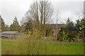
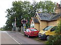
2
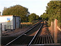
Crannaford level crossing looking east along the line
Image: © Rob Purvis
Taken: 1 Oct 2009
0.11 miles
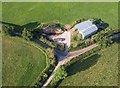
4
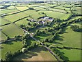
Crannaford from the air
The railway line from Exeter to Honiton cuts across diagonally on this side of the settlement. The lane is from Jack-in-the-Green to Broadclyst. Seen from a hot air balloon.
Image: © Derek Harper
Taken: 1 Jul 2009
0.12 miles
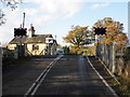
5

Railway line to Honiton at Crannaford Crossing
Image: © David Smith
Taken: 18 Sep 2011
0.13 miles
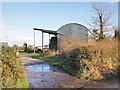
7
Lane junction near Crannaford
The upper arms of the Y form the lane between Jack-in-the-Green and Crannaford. The barn appears in Image Seen from a hot air balloon.
Image: © Derek Harper
Taken: 1 Jul 2009
0.14 miles
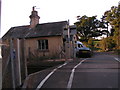
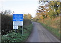
10
Crannaford Crossing
Presumably the building on the right was a house for the level crossing keeper
Image: © David Smith
Taken: 18 Sep 2011
0.17 miles