IMAGES TAKEN NEAR TO
Mead Cross, EXETER, EX5 7BG
Introduction
This page details the photographs taken nearby to Mead Cross, EX5 7BG by members of the Geograph project.
The Geograph project started in 2005 with the aim of publishing, organising and preserving representative images for every square kilometre of Great Britain, Ireland and the Isle of Man.

There are currently over 7.5m images from over14,400 individuals and you can help contribute to the project by visiting https://www.geograph.org.uk
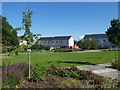
Image Map
Images are licensed for reuse under creativecommons.org/licenses/by-sa/2.0
Notes
- Clicking on the map will re-center to the selected point.
- The higher the marker number, the further away the image location is from the centre of the postcode.
Image Listing (45 Images Found)
Images are licensed for reuse under creativecommons.org/licenses/by-sa/2.0
Image
Details
Distance
1

Entrance to Hayes Place, and sign about play area, Cranbrook
Image: © David Smith
Taken: 11 Jul 2020
0.06 miles
4
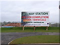
A new station to be built to serve Cranbrook
Image: © Sarah Charlesworth
Taken: 17 Apr 2013
0.08 miles

6
Cranbrook civic centre and health centre
Image: © David Smith
Taken: 11 Jul 2020
0.09 miles
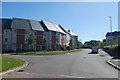
7
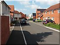
Cranbrook: Pitt Park
A street in the Cranbrook new town
Image: © Martin Bodman
Taken: 23 May 2018
0.10 miles
8
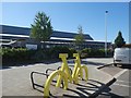
Cycle racks, Younghayes Road, Cranbrook
The yellow bicycle marks the Devon Stage of the Tour of Britain cycle race in September 2018. In the background is the school
Image: © David Smith
Taken: 11 Jul 2020
0.10 miles
9
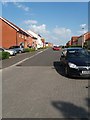
Cranbrook: Mayfield Way
A street in Cranbrook new town development
Image: © Martin Bodman
Taken: 23 May 2018
0.10 miles
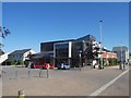
10

Coop supermarket, Younghayes Road, Cranbrook
Image: © David Smith
Taken: 11 Jul 2020
0.11 miles