IMAGES TAKEN NEAR TO
The Bury, EXETER, EX5 5NT
Introduction
This page details the photographs taken nearby to The Bury, EX5 5NT by members of the Geograph project.
The Geograph project started in 2005 with the aim of publishing, organising and preserving representative images for every square kilometre of Great Britain, Ireland and the Isle of Man.

There are currently over 7.5m images from over14,400 individuals and you can help contribute to the project by visiting https://www.geograph.org.uk
Image Map
Images are licensed for reuse under creativecommons.org/licenses/by-sa/2.0
Notes
- Clicking on the map will re-center to the selected point.
- The higher the marker number, the further away the image location is from the centre of the postcode.
Image Listing (107 Images Found)
Images are licensed for reuse under creativecommons.org/licenses/by-sa/2.0
Image
Details
Distance
1
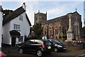
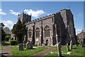
Thorverton : St Thomas a Becket's Church
The Gothic church of St Thomas a Becket was built from locally quarried stone in the late 15th early 16th centuries, although parts of it may date back to the 13th century. The western tower contains a clock and 10 bells, which date respectively from 1861, 1674, 1673 (4 and 6) the fifth from 1662 and the tenor was added in the late 90's. The church was successfully restored in 1834 when the nave was rebuilt.
Image: © Lewis Clarke
Taken: 16 Sep 2013
0.01 miles
2
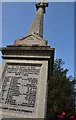
Thorverton : War Memorial Cross
A cross in St Thomas a Becket churchyard in Thorverton dedicated to those who fought in past conflict.
Image: © Lewis Clarke
Taken: 16 Sep 2013
0.01 miles
3
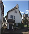
Golly Cottage, Thorverton
Golly Cottage is the half of a pair of thatched cottages that faces The Bury, the village street leading to St Thomas' church http://www.geograph.org.uk/search.php?i=12533425 ; Pine Cottage is the other half, and http://www.imagesofengland.org.uk/Details/Default.aspx?id=439076&mode=adv suggests that there were once three cottages in the range, and that it may have been a church house. "The gable end of Golly Cottage, facing the Bury is picturesquely irregular with a thatched porch canopy over a panelled front door. 3-light timber casements with small panes, 1 to ground floor, 1 to first floor and 1 to attic ... Scraps of leather and clay bobbins, the latter used for curling wigs, have been found under the attic floorboards indicating the workshop function of the roofspace".
Image: © Derek Harper
Taken: 4 May 2010
0.02 miles
4
Holly Cottage and Pine Cottage, Thorverton
Two lovely joined thatched cottages (that were possibly three). For more on this see Image by Derek Harper. Holly Cottage, the far one, has its entrance door facing the road named The Bury. Taken from the churchyard of St. Thomas a Becket's church.
Image: © Derek Voller
Taken: 15 Jun 2014
0.02 miles
5
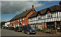
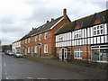
The Bury, Thorverton
Alas, not as car-free as when Roger visited Image Viewed from the junction with Bullen Street. On the right is a general stores.
Image: © Derek Harper
Taken: 18 Sep 2022
0.02 miles
6
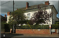
Berry House, Thorverton
On Bullen Street at its junction with The Bury (right). The house is listed https://historicengland.org.uk/listing/the-list/list-entry/1240387?section=official-list-entry .
Image: © Derek Harper
Taken: 18 Sep 2022
0.02 miles
7
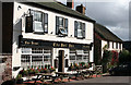
Thorverton: The Bell Inn
Not surprising The Bell stands opposite Thorverton church. The thatched cottage beyond is thought to be Abbotsford. Looking east-south-east
Image: © Martin Bodman
Taken: 7 Oct 2006
0.02 miles
8
St Thomas of Canterbury, Thorverton
Another view of the church shown in http://www.geograph.org.uk/search.php?i=12533425 , and which is C15 but much rebuilt in the C19.
Image: © Derek Harper
Taken: 4 May 2010
0.03 miles
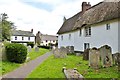
10
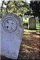
Thorverton : St Thomas a Becket's churchyard gravestones
Gravestones in the churchyard at St Thomas a Becket's Church in Thorverton.
Image: © Lewis Clarke
Taken: 16 Sep 2013
0.03 miles