IMAGES TAKEN NEAR TO
Lynch Close, EXETER, EX5 5NP
Introduction
This page details the photographs taken nearby to Lynch Close, EX5 5NP by members of the Geograph project.
The Geograph project started in 2005 with the aim of publishing, organising and preserving representative images for every square kilometre of Great Britain, Ireland and the Isle of Man.

There are currently over 7.5m images from over14,400 individuals and you can help contribute to the project by visiting https://www.geograph.org.uk
Image Map
Images are licensed for reuse under creativecommons.org/licenses/by-sa/2.0
Notes
- Clicking on the map will re-center to the selected point.
- The higher the marker number, the further away the image location is from the centre of the postcode.
Image Listing (74 Images Found)
Images are licensed for reuse under creativecommons.org/licenses/by-sa/2.0
Image
Details
Distance
1
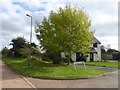
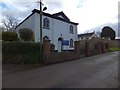
Lynch Close, Thorverton
A new development of six houses (all semi-detached)
Image: © David Smith
Taken: 4 Oct 2017
0.02 miles
2
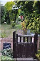
Thorverton : Tinkers Den
Looking up the garden path from the garden gate.
Image: © Lewis Clarke
Taken: 21 Jun 2015
0.08 miles
3
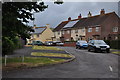
Thorverton : Cleaves Close
Cleaves Close is a small residential road in Thorverton.
Image: © Lewis Clarke
Taken: 21 Jun 2015
0.08 miles
4
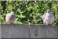
Thorverton : Pigeons
Pigeons on top of some of the garages.
Image: © Lewis Clarke
Taken: 21 Jun 2015
0.10 miles
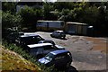
5
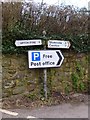
Thorverton : Car Park
A car park in Thorverton which is also home to the post office and a shop in a van.
Image: © Lewis Clarke
Taken: 16 Sep 2013
0.11 miles
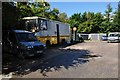
6
Thorverton : Car Park
The last shop - known as 'The Dairy' closed in 2006. The needs of the village have since been served by a second hand mobile ex-library vehicle situated in the car park.
Next to this vehicle, the business of the Post Office is conducted from a portable cabin. The original Post Office, now a private home in the centre of the village on the corner of Bullen Street and School Lane, was run by three generations of the Cummings family from 1870–1994, commemorated today by a blue plaque.
The car park itself was created on the site of a former quarry.
Image: © Lewis Clarke
Taken: 16 Sep 2013
0.12 miles
7
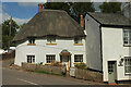
Thatched cottage, Thorverton
The listed Crossways, at the junction at the west end of the village, is described at https://historicengland.org.uk/listing/the-list/list-entry/1240384?section=official-list-entry / On the right is one of a row of three cottages, also listed https://historicengland.org.uk/listing/the-list/list-entry/1261041?section=official-list-entry .
Image: © Derek Harper
Taken: 18 Sep 2022
0.13 miles
8
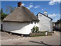
Cottage, Thorverton
This thatched coittage is at the junction of Dark Lane (left) and the lane from Chapel Cross. On the right is Bullen Street.
Image: © Derek Harper
Taken: 4 May 2010
0.13 miles
10
Old Direction Sign - Signpost by Bullen STreet, Thorverton
Onion finial - 2 arms, 1 Worboys; Devon simple by the UC road, in parish of Thorverton (Mid Devon District), Bullen Street junction with Dark Lane, by stone wall.
Surveyed
Milestone Society National ID: DV_SS9202
Image: © Alan Rosevear
Taken: 7 Feb 2013
0.13 miles