IMAGES TAKEN NEAR TO
Upexe, EXETER, EX5 5ND
Introduction
This page details the photographs taken nearby to EX5 5ND by members of the Geograph project.
The Geograph project started in 2005 with the aim of publishing, organising and preserving representative images for every square kilometre of Great Britain, Ireland and the Isle of Man.

There are currently over 7.5m images from over14,400 individuals and you can help contribute to the project by visiting https://www.geograph.org.uk
Image Map
Images are licensed for reuse under creativecommons.org/licenses/by-sa/2.0
Notes
- Clicking on the map will re-center to the selected point.
- The higher the marker number, the further away the image location is from the centre of the postcode.
Image Listing (21 Images Found)
Images are licensed for reuse under creativecommons.org/licenses/by-sa/2.0
Image
Details
Distance
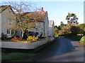
1
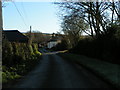
Up Exe: lane by Pale Farm
Looking east
Image: © Martin Bodman
Taken: 29 Jan 2006
0.04 miles
3
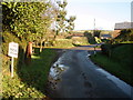
Slow, ducks crossing
Unusual warning sign at Up Exe.
Image: © Roger Cornfoot
Taken: 6 Dec 2008
0.06 miles
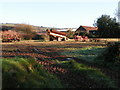
5
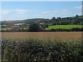
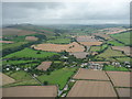
Mid Devon : Upexe & Countryside
Upexe can be seen with the A396 which runs between Tiverton and Exeter.
Image: © Lewis Clarke
Taken: 19 Aug 2008
0.07 miles
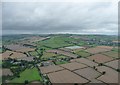
6
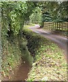
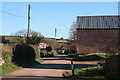
Ditch by the lane, Up Exe
The watercourse that runs alongside this lane ends up in the Exe, about 100 metres behind the camera.
Image: © Derek Harper
Taken: 23 Jul 2010
0.09 miles
7
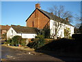
Mid Devon : Upexe Village & Countryside
Image: © Lewis Clarke
Taken: 19 Aug 2008
0.11 miles