IMAGES TAKEN NEAR TO
Cadbury, EXETER, EX5 5LB
Introduction
This page details the photographs taken nearby to EX5 5LB by members of the Geograph project.
The Geograph project started in 2005 with the aim of publishing, organising and preserving representative images for every square kilometre of Great Britain, Ireland and the Isle of Man.

There are currently over 7.5m images from over14,400 individuals and you can help contribute to the project by visiting https://www.geograph.org.uk
Image Map
Images are licensed for reuse under creativecommons.org/licenses/by-sa/2.0
Notes
- Clicking on the map will re-center to the selected point.
- The higher the marker number, the further away the image location is from the centre of the postcode.
Image Listing (17 Images Found)
Images are licensed for reuse under creativecommons.org/licenses/by-sa/2.0
Image
Details
Distance
1

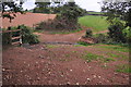
Lane at Ashley leading to Bowley
A minor road linking several farms south of Cadbury
Image: © David Smith
Taken: 17 Jun 2013
0.09 miles
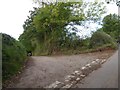
2

Mid Devon : Country Lane
A small lane heading through the Mid Devon countryside.
Image: © Lewis Clarke
Taken: 20 Sep 2014
0.10 miles
3

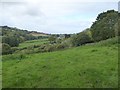
Mid Devon : Grassy Field & Countryside
Looking down into the River Jordan valley in Mid Devon.
Image: © Lewis Clarke
Taken: 20 Sep 2014
0.10 miles
5

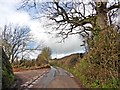
Mid Devon : Country Lane
A small lane heading alongside Parliament - not sure why it's called this.
Image: © Lewis Clarke
Taken: 20 Sep 2014
0.11 miles
6
The road to East Bowley
The trees and hedge give the impression of a tunnel
Image: © David Smith
Taken: 4 Oct 2017
0.12 miles
8
Mid Devon : Small Stream
The path heads across the River Jordan in Mid Devon.
Image: © Lewis Clarke
Taken: 20 Sep 2014
0.15 miles
9

Byway Ford at Armourwood Lane
This ford is found on a byway below a sixteenth century cottage called Parliament. This is where soldiers from Cadbury Castle stayed when they planned the route to siege Exeter. At that time there were three cottages at the location.
Image: © John Walton
Taken: 7 May 2021
0.16 miles
10

Scene on Milk Hill
Milk Hill is the lane behind the bank on the right, descending steeply past the oak trees (seen in the other direction in Image, which looks a lot less wintry).
Image: © Derek Harper
Taken: 3 Dec 2010
0.16 miles