IMAGES TAKEN NEAR TO
Cadbury, EXETER, EX5 5JT
Introduction
This page details the photographs taken nearby to EX5 5JT by members of the Geograph project.
The Geograph project started in 2005 with the aim of publishing, organising and preserving representative images for every square kilometre of Great Britain, Ireland and the Isle of Man.

There are currently over 7.5m images from over14,400 individuals and you can help contribute to the project by visiting https://www.geograph.org.uk
Image Map
Images are licensed for reuse under creativecommons.org/licenses/by-sa/2.0
Notes
- Clicking on the map will re-center to the selected point.
- The higher the marker number, the further away the image location is from the centre of the postcode.
Image Listing (15 Images Found)
Images are licensed for reuse under creativecommons.org/licenses/by-sa/2.0
Image
Details
Distance
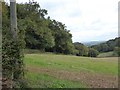
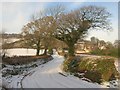
1
Track north of Terley
A farm track (not right of way) across the valley to near Fursdon House
Image: © David Smith
Taken: 4 Oct 2017
0.08 miles

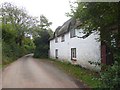
3
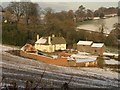
Terley, Cadbury
A farmhouse at the head of a deep valley below Cadbury Castle: "probably an early C18 rebuilding of an earlier house" http://www.britishlistedbuildings.co.uk/en-437257-terley-cadbury . Seen from Milk Hill.
Image: © Derek Harper
Taken: 3 Dec 2010
0.09 miles
4
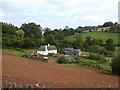
The farm at Terley
An 18th century farmhouse, listed grade II http://www.britishlistedbuildings.co.uk/en-437257-terley-cadbury
Image: © David Smith
Taken: 4 Oct 2017
0.09 miles
5
Buildings at Terley
The white building is listed grade II http://www.britishlistedbuildings.co.uk/en-437257-terley-cadbury
Image: © David Smith
Taken: 4 Oct 2017
0.10 miles
6
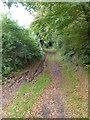
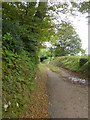
Green lane to Cadbury Castle
A public footpath
Image: © David Smith
Taken: 4 Oct 2017
0.10 miles
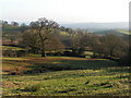
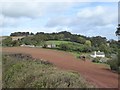
8
Field by Castle Wood, Cadbury
The footpath to Cadbury Castle runs along the edge of the field
Image: © David Smith
Taken: 4 Oct 2017
0.15 miles
10
Lane past Cadbury House
The lane at the top of Milk Hill, turning a bend to run across a col between the heads of two valleys that meet at Thorverton. On the right is the former vicarage, Cadbury House http://www.britishlistedbuildings.co.uk/en-437164-cadbury-house-cadbury . Ahead, the lane bends left, with Cadbury Castle on the hill behind.
Image: © Derek Harper
Taken: 3 Dec 2010
0.18 miles