IMAGES TAKEN NEAR TO
Thorverton, EXETER, EX5 5JN
Introduction
This page details the photographs taken nearby to EX5 5JN by members of the Geograph project.
The Geograph project started in 2005 with the aim of publishing, organising and preserving representative images for every square kilometre of Great Britain, Ireland and the Isle of Man.

There are currently over 7.5m images from over14,400 individuals and you can help contribute to the project by visiting https://www.geograph.org.uk
Image Map
Images are licensed for reuse under creativecommons.org/licenses/by-sa/2.0
Notes
- Clicking on the map will re-center to the selected point.
- The higher the marker number, the further away the image location is from the centre of the postcode.
Image Listing (9 Images Found)
Images are licensed for reuse under creativecommons.org/licenses/by-sa/2.0
Image
Details
Distance
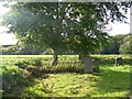
1
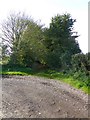
Overgrown lane, near Netherexe
The western end of Green Lane from Rewe to the River Exe
Image: © David Smith
Taken: 25 Oct 2015
0.18 miles
2
![East Devon : Burrow Road [Track]](https://s1.geograph.org.uk/geophotos/03/14/89/3148949_92c0cfb0_120x120.jpg)
East Devon : Burrow Road [Track]
A small track which if followed heads towards the A396.
Image: © Lewis Clarke
Taken: 21 Sep 2012
0.22 miles
3
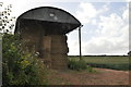
East Devon : Barn & Field
A barn in the field in East Devon.
Image: © Lewis Clarke
Taken: 21 Jun 2015
0.22 miles
4
Fortescue Cross and the road to Fortescue
Image: © David Smith
Taken: 21 Feb 2011
0.22 miles
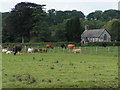
5
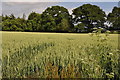
East Devon : Grassy Field
A grassy field near Brampford Speke in East Devon.
Image: © Lewis Clarke
Taken: 21 Jun 2015
0.24 miles
6
Fence around a grave, Netherexe churchyard
The churchyard is surrounded with a low earth wall which protects it from some flooding by the nearby River Exe
Image: © David Smith
Taken: 25 Oct 2015
0.24 miles
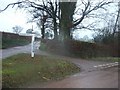
8
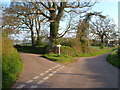
Fortescue Cross
Junction of lanes on a river terrace in the Exe valley.
Image: © Derek Harper
Taken: 27 Apr 2006
0.25 miles
9
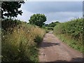
Green Lane
Green Lane both in name and characteristic. Heading towards the River Exe, but not reaching it, it is followed by the parish boundary between Stoke Canon (left) and Nether Exe, and, briefly here, by the Exe Valley Way.
Image: © Derek Harper
Taken: 23 Jul 2010
0.25 miles