IMAGES TAKEN NEAR TO
Thorverton, EXETER, EX5 5DN
Introduction
This page details the photographs taken nearby to EX5 5DN by members of the Geograph project.
The Geograph project started in 2005 with the aim of publishing, organising and preserving representative images for every square kilometre of Great Britain, Ireland and the Isle of Man.

There are currently over 7.5m images from over14,400 individuals and you can help contribute to the project by visiting https://www.geograph.org.uk
Image Map
Images are licensed for reuse under creativecommons.org/licenses/by-sa/2.0
Notes
- Clicking on the map will re-center to the selected point.
- The higher the marker number, the further away the image location is from the centre of the postcode.
Image Listing (7 Images Found)
Images are licensed for reuse under creativecommons.org/licenses/by-sa/2.0
Image
Details
Distance
1
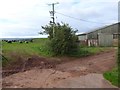
Field and barn by Thatcher's Lane, north of Thorverton
Image: © David Smith
Taken: 4 Oct 2017
0.02 miles
2
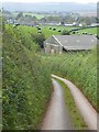
Thatcher's Lane, looking south to Thorverton
Houses in Thorverton in the distance
Image: © David Smith
Taken: 4 Oct 2017
0.07 miles
3
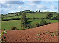
Valley below Fursdon
Looking across the valley from Northdown Road, with the red field shown in Image in the foreground. As with that image, Raddon Hill is on the skyline.
Image: © Derek Harper
Taken: 20 Oct 2010
0.11 miles
4
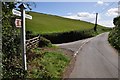
Mid Devon : Ford Cross
Ford Cross in Mid Devon with a signpost giving directions to Thorverton and Fursdon.
Image: © Lewis Clarke
Taken: 16 Sep 2013
0.18 miles
5
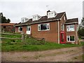
House at Ford Cross
Interesting use of old telephone box as a mini-greenhouse.
Image: © Roger Cornfoot
Taken: 30 Sep 2017
0.19 miles
6
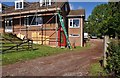
Mid Devon : Meadow Farm
A house on Meadow Farm near Thorverton in Mid Devon.
Image: © Lewis Clarke
Taken: 16 Sep 2013
0.19 miles
7
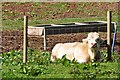
Mid Devon : Meadow Farm Bull
A bull lying in a field at Meadow Farm in Mid Devon.
Image: © Lewis Clarke
Taken: 16 Sep 2013
0.21 miles