IMAGES TAKEN NEAR TO
Newton St. Cyres, EXETER, EX5 5BG
Introduction
This page details the photographs taken nearby to EX5 5BG by members of the Geograph project.
The Geograph project started in 2005 with the aim of publishing, organising and preserving representative images for every square kilometre of Great Britain, Ireland and the Isle of Man.

There are currently over 7.5m images from over14,400 individuals and you can help contribute to the project by visiting https://www.geograph.org.uk
Image Map
Images are licensed for reuse under creativecommons.org/licenses/by-sa/2.0
Notes
- Clicking on the map will re-center to the selected point.
- The higher the marker number, the further away the image location is from the centre of the postcode.
Image Listing (135 Images Found)
Images are licensed for reuse under creativecommons.org/licenses/by-sa/2.0
Image
Details
Distance
1

Woodlands, Newton St Cyres
A small modern development
Image: © David Smith
Taken: 18 Apr 2017
0.03 miles

3
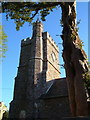
St Cyriac and St Julitta's church, Newton St Cyres
The tower of the church dedicated to mother and son martyrs. The church straddles a grid line.
Image: © Derek Harper
Taken: 5 May 2006
0.05 miles
4
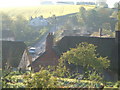
Newton St Cyres
Houses appear to steam in the early morning sun (7:17 am). Seen from the churchyard, with the A377 on the left.
Image: © Derek Harper
Taken: 5 May 2006
0.05 miles

6
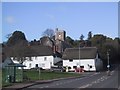
Newton St Cyres
Centre of the village taken across the A377.
Image: © Sarah Charlesworth
Taken: 1 Mar 2008
0.08 miles
7
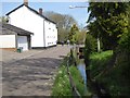
Road and stream, West Town, Newton St Cyres
Image: © David Smith
Taken: 18 Apr 2017
0.09 miles
8
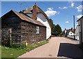
West Town Road, Newton St Cyres
A timber outhouse adjoins a row of three cottages on the left, also shown in Image http://www.imagesofengland.org.uk/Details/Default.aspx?id=96389&mode=adv suggests that the "irregularity of {the} cottages suggests that they were built at different dates, or were the result of the C18 sub-division of a larger building". Across the A377 in the background is number 4, described at http://www.imagesofengland.org.uk/Details/Default.aspx?id=96387&mode=adv .
Image: © Derek Harper
Taken: 4 May 2010
0.09 miles
9

Newton St Cyres : Village Scenery
Looking down towards Newton St Cyres.
Image: © Lewis Clarke
Taken: 4 Dec 2019
0.09 miles
10

Newton St Cyres : St Cyr and St Julitta Church
The oldest part of the church is the west tower, built in the late 13th century, but the bulk of the church we see today is 14th century, with the addition of a 16th century north aisle.
Image: © Lewis Clarke
Taken: 30 Jul 2016
0.09 miles