IMAGES TAKEN NEAR TO
Newton St. Cyres, EXETER, EX5 5AF
Introduction
This page details the photographs taken nearby to EX5 5AF by members of the Geograph project.
The Geograph project started in 2005 with the aim of publishing, organising and preserving representative images for every square kilometre of Great Britain, Ireland and the Isle of Man.

There are currently over 7.5m images from over14,400 individuals and you can help contribute to the project by visiting https://www.geograph.org.uk
Image Map
Images are licensed for reuse under creativecommons.org/licenses/by-sa/2.0
Notes
- Clicking on the map will re-center to the selected point.
- The higher the marker number, the further away the image location is from the centre of the postcode.
Image Listing (24 Images Found)
Images are licensed for reuse under creativecommons.org/licenses/by-sa/2.0
Image
Details
Distance
1
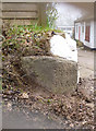
Old Boundary Marker by the A377, Newbridge Hill, Upton Pyne
Parish Boundary Marker on the East side of the A377, on the boundary of Newton St Cyres and Upton Pyne parishes (Mid Devon District), sited on the verge by the driveway to No. 1 Newbridge Hill, 250 metres Southeast of Newbridge Cross.
Inscription reads: NEW / TON / S.T. / (CYRES) / (P) on the left face and UPTON / PYNE / P on the right face
Devon & Dartmoor HER.
HER Number: MDV76411 https://www.heritagegateway.org.uk/Gateway/Results_Single.aspx?uid=MDV76411&resourceID=104
Milestone Society National ID: DV_EXBS02pb
Image: © Alan Rosevear
Taken: 5 Mar 2013
0.01 miles
2
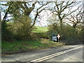
Foot path to Half Moon Village
A cross country route avoiding the busy main road.
Image: © Anthony Vosper
Taken: 25 Mar 2023
0.02 miles
3
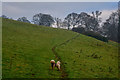
Upton Pyne : Grassy Field
A muddy path and Molly the dog heading through the field.
Image: © Lewis Clarke
Taken: 4 Dec 2019
0.05 miles
4
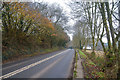
Upton Pyne : Newbridge Hill A377
Looking along Newbridge Hill.
Image: © Lewis Clarke
Taken: 4 Dec 2019
0.06 miles
5
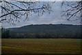
Upton Pyne : Grassy Field
A grassy field in the Upton Pyne parish.
Image: © Lewis Clarke
Taken: 4 Dec 2019
0.07 miles
6
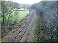
Tarka Line
Taken from New Bridge looking southeast in the direction of Cowley Bridge Junction on the Exeter to Crediton line which was opened in 1851.
Image: © Peter Holmes
Taken: 12 Dec 2007
0.09 miles
7
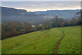
Newton St Cyres : Grassy Field
The footpath heads through the field.
Image: © Lewis Clarke
Taken: 4 Dec 2019
0.10 miles
8
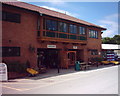
Garden Centre at Three Horse Shoes, near Exeter
New garden centre building under construction at Bernaville Nurseries, Cowley Bridge, Exeter
Image: © David Smith
Taken: 12 Jun 2005
0.14 miles
9
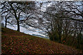
Newton St Cyres : Grassy Field
Heading through a small patch of woodland.
Image: © Lewis Clarke
Taken: 4 Dec 2019
0.16 miles
10
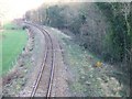
Tarka line from New Bridge
The woodland to the right is Newbridge (one word) Wood
Image: © David Smith
Taken: 7 Mar 2011
0.16 miles