IMAGES TAKEN NEAR TO
Dukes Orchard, EXETER, EX5 4RA
Introduction
This page details the photographs taken nearby to Dukes Orchard, EX5 4RA by members of the Geograph project.
The Geograph project started in 2005 with the aim of publishing, organising and preserving representative images for every square kilometre of Great Britain, Ireland and the Isle of Man.

There are currently over 7.5m images from over14,400 individuals and you can help contribute to the project by visiting https://www.geograph.org.uk
Image Map
Images are licensed for reuse under creativecommons.org/licenses/by-sa/2.0
Notes
- Clicking on the map will re-center to the selected point.
- The higher the marker number, the further away the image location is from the centre of the postcode.
Image Listing (127 Images Found)
Images are licensed for reuse under creativecommons.org/licenses/by-sa/2.0
Image
Details
Distance
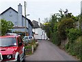
1

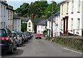
Bradninch : Dukes Orchard
A residential road in Bradninch.
Image: © Lewis Clarke
Taken: 2 Jan 2018
0.01 miles
2
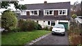
Bradninch : Dukes Orchard Houses
Houses on Dukes Orchard in Bradninch
Image: © Lewis Clarke
Taken: 2 Jan 2018
0.03 miles
3
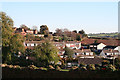
Bradninch: housing near West End
Seen from West End
Image: © Martin Bodman
Taken: 18 Nov 2005
0.06 miles
4
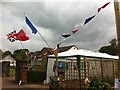
Stall on Hele Road, Bradninch, celebrating Bradninch-Landunvez twinning
Stall in a driveway on Hele Road, Bradninch, celebrating with flags and bunting the village-twinning friendship between Bradninch in Devon, England, UK and Landunvez in Brittany, France. Photo taken on 1st June 2014, in happier, pre-Brexit, times for Anglo-French relations.
Image: © A J Paxton
Taken: 1 Jun 2014
0.09 miles
6
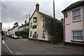
Bradninch the White Lion
Very quiet village on this afternoon.
Image: © roger geach
Taken: 24 Nov 2011
0.10 miles
7
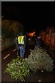
Bradninch : Kensham Avenue
People drag their Christmas trees through the streets to be burnt.
Image: © Lewis Clarke
Taken: 6 Jan 2022
0.11 miles
9
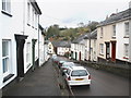
West End Road - Bradninch
Also known as the High Street, West End Road is steep with raised pavements. The White Lion pub is at the bottom.
Image: © Sarah Smith
Taken: 31 May 2010
0.12 miles
10
The south-west end of Culver Close
This end of the Close has older houses; it has been extended with modern houses and bungalows.
Image: © David Smith
Taken: 26 Jul 2011
0.12 miles