IMAGES TAKEN NEAR TO
Cranishaies Lane, EXETER, EX5 4LJ
Introduction
This page details the photographs taken nearby to Cranishaies Lane, EX5 4LJ by members of the Geograph project.
The Geograph project started in 2005 with the aim of publishing, organising and preserving representative images for every square kilometre of Great Britain, Ireland and the Isle of Man.

There are currently over 7.5m images from over14,400 individuals and you can help contribute to the project by visiting https://www.geograph.org.uk
Image Map
Images are licensed for reuse under creativecommons.org/licenses/by-sa/2.0
Notes
- Clicking on the map will re-center to the selected point.
- The higher the marker number, the further away the image location is from the centre of the postcode.
Image Listing (16 Images Found)
Images are licensed for reuse under creativecommons.org/licenses/by-sa/2.0
Image
Details
Distance
1
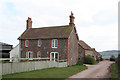
Cullompton: Highdown Farm
One of a number of Duchy of Cornwall farms around Cullompton and Bradninch and one that is listed on the Devon Farms website: http://www.devonfarms.co.uk
The house nearest the camera is New Cott and is seen looking south
Image: © Martin Bodman
Taken: 21 Mar 2006
0.03 miles
2
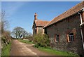
Highdown
A reverse view of Image, with Cranishaies Lane passing the buildings shown. The trees on the left are shown in Image
Image: © Derek Harper
Taken: 19 Mar 2011
0.04 miles
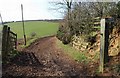
3
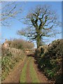
Cranishaies Lane
The green lane climbs to Highdown. Image was taken from just beside the oak.
Image: © Derek Harper
Taken: 19 Mar 2011
0.05 miles
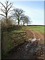
4
Track, Highdown
From Cranishaies Lane, which here, south of Highdown, is a green lane dropping down a steep valley towards the Culm.
Image: © Derek Harper
Taken: 19 Mar 2011
0.07 miles
5
Track across field, Highdown
Looking left from the same spot as Image on Cranishaies Lane.
Image: © Derek Harper
Taken: 19 Mar 2011
0.07 miles
6
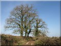
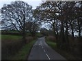
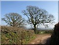
Trees on Cranishaies Lane
Looking north along the lane from close to Highdown, with oaks.
Image: © Derek Harper
Taken: 19 Mar 2011
0.08 miles
7
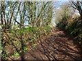
Cranishaies Lane
The green lane, a route with public access, climbs between banks and coppiced trees towards Highdown.
Image: © Derek Harper
Taken: 19 Mar 2011
0.18 miles
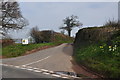
8
Cranishaies Lane
Oaks overlook a right-angled bend on the no through lane leading to Image
Image: © Derek Harper
Taken: 19 Mar 2011
0.19 miles
9
Mid Devon : Cranishaies Lane
A small road heading towards Highdown Farm in Mid Devon.
Image: © Lewis Clarke
Taken: 29 Mar 2014
0.21 miles