IMAGES TAKEN NEAR TO
Livingshayes Road, EXETER, EX5 4JW
Introduction
This page details the photographs taken nearby to Livingshayes Road, EX5 4JW by members of the Geograph project.
The Geograph project started in 2005 with the aim of publishing, organising and preserving representative images for every square kilometre of Great Britain, Ireland and the Isle of Man.

There are currently over 7.5m images from over14,400 individuals and you can help contribute to the project by visiting https://www.geograph.org.uk
Image Map
Images are licensed for reuse under creativecommons.org/licenses/by-sa/2.0
Notes
- Clicking on the map will re-center to the selected point.
- The higher the marker number, the further away the image location is from the centre of the postcode.
Image Listing (49 Images Found)
Images are licensed for reuse under creativecommons.org/licenses/by-sa/2.0
Image
Details
Distance


3
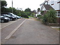
Park Close
Public footpath Silverton 10.
Image: © Peter Holmes
Taken: 27 Sep 2014
0.07 miles
4
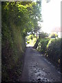
Livingshayes Road Silverton
A dead-end lane leading to Livingshayes Farm.
Image: © Rod Allday
Taken: 14 Oct 2012
0.08 miles
5

Path to Park Close
Public footpath Silverton 10.
Image: © Peter Holmes
Taken: 27 Sep 2014
0.09 miles

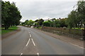
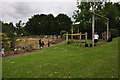
8

Road outside Silverton Primary School
P711 FTV and Y709 JYA parked.
Image: © Rob Purvis
Taken: 28 Apr 2009
0.10 miles
9
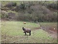
Horses in the valley of Heal-Eye Stream
The stream runs through the bushes beyond the field
Image: © David Smith
Taken: 20 Feb 2012
0.10 miles
10
Silverton : Silverton Primary School
Out in the school grounds of Silverton.
Image: © Lewis Clarke
Taken: 16 Jun 2015
0.10 miles