IMAGES TAKEN NEAR TO
Huxham, EXETER, EX5 4EN
Introduction
This page details the photographs taken nearby to EX5 4EN by members of the Geograph project.
The Geograph project started in 2005 with the aim of publishing, organising and preserving representative images for every square kilometre of Great Britain, Ireland and the Isle of Man.

There are currently over 7.5m images from over14,400 individuals and you can help contribute to the project by visiting https://www.geograph.org.uk
Image Map
Images are licensed for reuse under creativecommons.org/licenses/by-sa/2.0
Notes
- Clicking on the map will re-center to the selected point.
- The higher the marker number, the further away the image location is from the centre of the postcode.
Image Listing (7 Images Found)
Images are licensed for reuse under creativecommons.org/licenses/by-sa/2.0
Image
Details
Distance
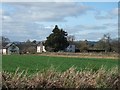
4
Looking across the fields, towards Bussells Farm
Image: © Roger Cornfoot
Taken: 21 Feb 2010
0.04 miles
5
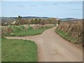
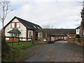
Entrance to Bussell's farm
Country road north of Huxham passing Bussell's farm
Image: © David Smith
Taken: 17 Mar 2011
0.13 miles
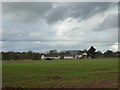
6

Junction near Brookleigh
The main lane, following the southeast side of the Culm valley, leads to Huxham; the left turn is for Poltimore.
Image: © Derek Harper
Taken: 23 Mar 2006
0.19 miles
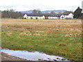
7

Thatched cottages at Brookleigh
Part of a mainly residential hamlet in the flat Culm valley. looking east.
Image: © Derek Harper
Taken: 23 Mar 2006
0.23 miles