IMAGES TAKEN NEAR TO
Stoke Hill, EXETER, EX5 4EE
Introduction
This page details the photographs taken nearby to Stoke Hill, EX5 4EE by members of the Geograph project.
The Geograph project started in 2005 with the aim of publishing, organising and preserving representative images for every square kilometre of Great Britain, Ireland and the Isle of Man.

There are currently over 7.5m images from over14,400 individuals and you can help contribute to the project by visiting https://www.geograph.org.uk
Image Map
Images are licensed for reuse under creativecommons.org/licenses/by-sa/2.0
Notes
- Clicking on the map will re-center to the selected point.
- The higher the marker number, the further away the image location is from the centre of the postcode.
Image Listing (26 Images Found)
Images are licensed for reuse under creativecommons.org/licenses/by-sa/2.0
Image
Details
Distance
1
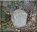
Old Milestone by the A396, south of Stoke Canon
Carved stone post by the A396, in parish of STOKE CANON (EAST DEVON District), 50m South of Culm Vale entrance, South of the bridge over River Culm, in ditch under oak tree, on North side of road. Exeter tombstone, erected by the Exeter turnpike trust in the 19th century.
Inscription reads:- : 4 / MILES / FROM / EXETER :
Carved benchmark and rivet on upper right side.
Milestone Society National ID: DV_EXTT04.
Image: © Alan Rosevear
Taken: 16 Apr 2011
0.06 miles
3
Causeway, Stoke Canon
The A396 crosses the flood plain of the River Culm. There are bridges over the river channel, subsidiary streams and a mill leat. It is a bottleneck, not wide enough for two lorries to pass in places.
Image: © David Smith
Taken: 1 Nov 2010
0.11 miles

5
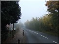
A396 in the southern part of Stoke Canon
Image: © David Smith
Taken: 1 Nov 2010
0.12 miles
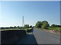
6
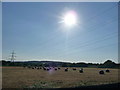
Stoke Canon : Hay Bales, Field & Electricity Pylons
Image: © Lewis Clarke
Taken: 1 Jun 2009
0.15 miles
7

Stoke Cannon : Pylons & Floodplain
The national grid heads towards Exeter.
Image: © Lewis Clarke
Taken: 13 Nov 2005
0.15 miles
8
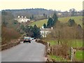
Stoke Canon causeway
An awkward stretch of the A396, crossing the Culm flood plain on a C15 causeway http://list.english-heritage.org.uk/resultsingle.aspx?uid=1253020&searchtype=mapsearch , especially if you meet a bus. The house parly painted blue is the C17 and C19 Culm Vale http://list.english-heritage.org.uk/resultsingle.aspx?uid=1333982&searchtype=mapsearch . The prominent white house above left is Culmleigh.
Image: © Derek Harper
Taken: 16 Mar 2006
0.15 miles
9
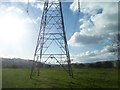
Stoke Cannon : Pylons & Floodplain
Pylons heading towards Exeter.
Image: © Lewis Clarke
Taken: 13 Nov 2005
0.17 miles
