IMAGES TAKEN NEAR TO
Netherexe, EXETER, EX5 4DZ
Introduction
This page details the photographs taken nearby to EX5 4DZ by members of the Geograph project.
The Geograph project started in 2005 with the aim of publishing, organising and preserving representative images for every square kilometre of Great Britain, Ireland and the Isle of Man.

There are currently over 7.5m images from over14,400 individuals and you can help contribute to the project by visiting https://www.geograph.org.uk
Image Map
Images are licensed for reuse under creativecommons.org/licenses/by-sa/2.0
Notes
- Clicking on the map will re-center to the selected point.
- The higher the marker number, the further away the image location is from the centre of the postcode.
Image Listing (17 Images Found)
Images are licensed for reuse under creativecommons.org/licenses/by-sa/2.0
Image
Details
Distance
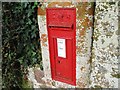
1
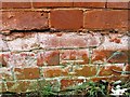
Kitts Lane, Nether Exe
The wallbox is dated Edward VII Image
Image: © David Smith
Taken: 25 Oct 2015
0.06 miles

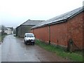
5
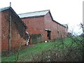
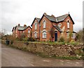
In Nether Exe; farm buildings
This forms the east wall of the buildings in Image
Image: © David Smith
Taken: 21 Feb 2011
0.11 miles
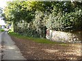
9
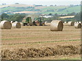
In Nether Exe
This lane through Nether Exe runs almost due east-west along a myriad gridline; this picture is to the north, but the white buildings are to the south of the gridline.
Image: © David Smith
Taken: 21 Feb 2011
0.13 miles