IMAGES TAKEN NEAR TO
Silverton, EXETER, EX5 4DS
Introduction
This page details the photographs taken nearby to EX5 4DS by members of the Geograph project.
The Geograph project started in 2005 with the aim of publishing, organising and preserving representative images for every square kilometre of Great Britain, Ireland and the Isle of Man.

There are currently over 7.5m images from over14,400 individuals and you can help contribute to the project by visiting https://www.geograph.org.uk
Image Map
Images are licensed for reuse under creativecommons.org/licenses/by-sa/2.0
Notes
- Clicking on the map will re-center to the selected point.
- The higher the marker number, the further away the image location is from the centre of the postcode.
Image Listing (19 Images Found)
Images are licensed for reuse under creativecommons.org/licenses/by-sa/2.0
Image
Details
Distance
1
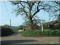
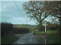
Poundsland Cross and Poundsland Cottages
The road ahead leads to Silverton. The one which crosses is known as Babylon Lane
Image: © David Smith
Taken: 19 Mar 2011
0.02 miles
2
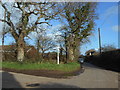
Poundslands Cross
A small junction outside Silverton.
Very little has changed here since Image was taken 6 years previously.
The Oak tree on the right bears the scars of being struck by lightning.
Image: © Anthony Vosper
Taken: 1 Feb 2020
0.02 miles
3
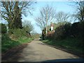
Mid Devon : Country Lane
A road heading towards the village of Silverton in Mid Devon.
Image: © Lewis Clarke
Taken: 16 Feb 2014
0.02 miles
4
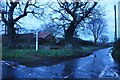
Mid Devon : Poundsland Cross
At the road junction at Poundsland Cross with the signpost giving directions to Bradninch, Thorverton, Rewe and Silverton.
Image: © Lewis Clarke
Taken: 16 Feb 2014
0.02 miles
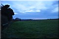
6
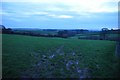
Mid Devon : Grassy Field
A grassy field in the Mid Devon countryside near Silverton.
Image: © Lewis Clarke
Taken: 16 Feb 2014
0.05 miles
7
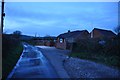
View along Babylon Lane near Poundsland Cross
Hayne Lane crosses a short distance ahead, just beyond the house.
Image: © David Smith
Taken: 19 Mar 2011
0.06 miles
8
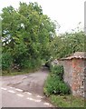
Hayne Lane
Silverton Footpath 5 follows this narrow lane from the crossroads at Waterleat House and continues into the Culm valley after the public road ends at Lower Hayne. On the right, a brick and stone wall roofed with tiles.
Image: © Derek Harper
Taken: 23 Jul 2010
0.08 miles
9

Stile on a permissive footpath near Silverton Park Farm
Image: © Rod Allday
Taken: 14 Oct 2012
0.11 miles
10
Mid Devon : Grassy Field
A grassy field in the Mid Devon countryside.
Image: © Lewis Clarke
Taken: 16 Feb 2014
0.11 miles