IMAGES TAKEN NEAR TO
Silverton, EXETER, EX5 4BZ
Introduction
This page details the photographs taken nearby to EX5 4BZ by members of the Geograph project.
The Geograph project started in 2005 with the aim of publishing, organising and preserving representative images for every square kilometre of Great Britain, Ireland and the Isle of Man.

There are currently over 7.5m images from over14,400 individuals and you can help contribute to the project by visiting https://www.geograph.org.uk
Image Map
Images are licensed for reuse under creativecommons.org/licenses/by-sa/2.0
Notes
- Clicking on the map will re-center to the selected point.
- The higher the marker number, the further away the image location is from the centre of the postcode.
Image Listing (44 Images Found)
Images are licensed for reuse under creativecommons.org/licenses/by-sa/2.0
Image
Details
Distance
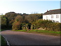
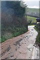
2
Mid Devon : Country Lane
A country lane which heads up the hill, with lots of water heading down it.
Image: © Lewis Clarke
Taken: 18 Jan 2014
0.01 miles
3
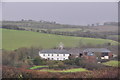
Mid Devon : Countryside Scenery
Looking across to Great Dorweeke and the surroundings.
Image: © Lewis Clarke
Taken: 18 Jan 2014
0.01 miles
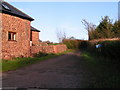
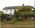
4
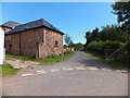
Barn at Great Dorweeke
The track is unsuitable for motors, as it rapidly deteriorates to a track
Image: © David Smith
Taken: 26 Jul 2011
0.01 miles
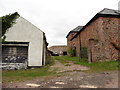
5
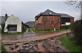
Mid Devon : Great Dorweeke
A country lane with lots of water beside Great Dorweeke.
Image: © Lewis Clarke
Taken: 18 Jan 2014
0.02 miles
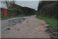
8
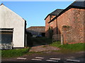
Mid Devon : Country Lane
A country lane with what seems to be a small stream running down it.
Image: © Lewis Clarke
Taken: 18 Jan 2014
0.02 miles