IMAGES TAKEN NEAR TO
Beare, Broadclyst, EXETER, EX5 3LA
Introduction
This page details the photographs taken nearby to EX5 3LA by members of the Geograph project.
The Geograph project started in 2005 with the aim of publishing, organising and preserving representative images for every square kilometre of Great Britain, Ireland and the Isle of Man.

There are currently over 7.5m images from over14,400 individuals and you can help contribute to the project by visiting https://www.geograph.org.uk
Image Map
Images are licensed for reuse under creativecommons.org/licenses/by-sa/2.0
Notes
- Clicking on the map will re-center to the selected point.
- The higher the marker number, the further away the image location is from the centre of the postcode.
Image Listing (16 Images Found)
Images are licensed for reuse under creativecommons.org/licenses/by-sa/2.0
Image
Details
Distance
1
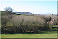
Broadclyst: copse on the site of a pond
The dried-out pond once served the tanpits of Beare Tannery, which stood on the far side of the B3181 Cullompton – Exeter road. The trees of Killerton Park appear on the skyline above the immediate hill. Looking west from the lane to Frogmore Cross
Image: © Martin Bodman
Taken: 29 Jan 2006
0.04 miles


4

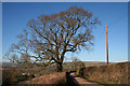
Turning on the B3181, for Clyst St Lawrence
Image: © Roger Cornfoot
Taken: 8 Apr 2010
0.10 miles
5
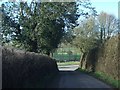
Broadclyst: north from Lower Comberoy
A lane leading to the B3181 Cullompton – Exeter road, a little to the north of the site of a holy well. Looking north; to the west a valley runs down to Beare
Image: © Martin Bodman
Taken: 29 Jan 2006
0.11 miles
6
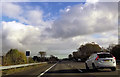
Junction with B3181 near Beare
Cars can be seen on the M5 beyond the B3181. Until the M5 was opened the B3181 was named the A38.
Image: © David Smith
Taken: 19 Feb 2011
0.12 miles
8
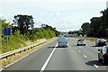
Northbound M5 near Beare
Passing Driver Location Sign B245.5
Driver location signs are now widely used across the motorway and A–road network. First introduced in 2003, they complement distance marker posts. Both types of marker post display the distances in kilometres from a nominal start point but driver location signs are designed to be read by motorists or their passengers when, for instance, they need to pass details to the emergency services. They give the same location information as distance marker posts, but more visibly on larger signs. They are normally spaced at 500-metre intervals along the nearside verge but if obstacles (eg sliproads or bridges) prevent signs from being erected at these locations, then the interval is reduced to either 400 or 300 metres.
Driver location signs display three pieces of information:
• The road identifier (eg M5 in this example)
• The carriageway identifier – The letter on the second line of the signs, usually “A” or “B”, tells the emergency services or the Highways Agency in which direction you are travelling. The letter “A” ("Away from London") normally denotes carriageways leaving London and "B" ("Back to London") is used for carriageways going to London. In this example, "B" tells us that we are on the northbound carriageway, travelling away from London.
• The location (which is identical to the location given on marker posts). Distances are accurate to within 20 metres and are generally quoted from the beginning of the motorway. In this example, we are 248 km from the start of the motorway.
http://www.dft.gov.uk/ha/standards/ians/pdfs/ian93r1.pdf DFT Interim Advice Note (December 2010)
http://www.theaa.com/motoring_advice/breakdown_advice/driver-location-signs.html The AA
http://www.sabre-roads.org.uk/wiki/index.php?title=Driver_Location_Signs SABREPassing Driver Location Sign B248.0
Image: © David Dixon
Taken: 25 Jul 2018
0.13 miles

10
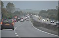
East Devon : The M5 Motorway
A gloomy afternoon heading up the M5 Motorway through Devon.
Image: © Lewis Clarke
Taken: 5 Nov 2013
0.16 miles