IMAGES TAKEN NEAR TO
Budlake, EXETER, EX5 3JT
Introduction
This page details the photographs taken nearby to EX5 3JT by members of the Geograph project.
The Geograph project started in 2005 with the aim of publishing, organising and preserving representative images for every square kilometre of Great Britain, Ireland and the Isle of Man.

There are currently over 7.5m images from over14,400 individuals and you can help contribute to the project by visiting https://www.geograph.org.uk
Image Map
Images are licensed for reuse under creativecommons.org/licenses/by-sa/2.0
Notes
- Clicking on the map will re-center to the selected point.
- The higher the marker number, the further away the image location is from the centre of the postcode.
Image Listing (15 Images Found)
Images are licensed for reuse under creativecommons.org/licenses/by-sa/2.0
Image
Details
Distance
1

Fields near Hollis Head
Looking north from the lane seen in Image, across red fields.
Image: © Derek Harper
Taken: 13 May 2010
0.12 miles
2
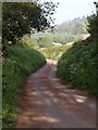
Lane to Budlake
The lane from Rewes Cross descends between banks. Buildings at Budlake Farm are visible ahead, with the hill at Killerton in the distance.
Image: © Derek Harper
Taken: 13 May 2010
0.13 miles
4
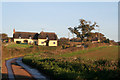
Broadclyst: Hollis Head cottages
On the lane between Budlake and Frogmore Cross
Image: © Martin Bodman
Taken: 20 Nov 2005
0.21 miles
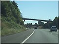
5
East Devon : The M5 Motorway
Heading along the M5 Motorway towards Exeter.
Image: © Lewis Clarke
Taken: 23 Feb 2014
0.21 miles

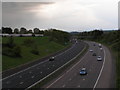
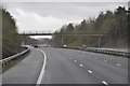
7

East Devon : The M5 Motorway
Looking across to the northbound section of the M5 Motorway.
Image: © Lewis Clarke
Taken: 26 Nov 2012
0.22 miles
8
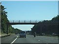
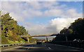
Motorway bridge for track near Budlake
This bridge carries a farm track
Image: © David Smith
Taken: 30 Aug 2010
0.23 miles