IMAGES TAKEN NEAR TO
Broadclyst, EXETER, EX5 3JQ
Introduction
This page details the photographs taken nearby to EX5 3JQ by members of the Geograph project.
The Geograph project started in 2005 with the aim of publishing, organising and preserving representative images for every square kilometre of Great Britain, Ireland and the Isle of Man.

There are currently over 7.5m images from over14,400 individuals and you can help contribute to the project by visiting https://www.geograph.org.uk
Image Map
Images are licensed for reuse under creativecommons.org/licenses/by-sa/2.0
Notes
- Clicking on the map will re-center to the selected point.
- The higher the marker number, the further away the image location is from the centre of the postcode.
Image Listing (8 Images Found)
Images are licensed for reuse under creativecommons.org/licenses/by-sa/2.0
Image
Details
Distance
1
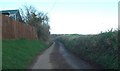
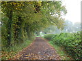
The road to Burrow Cross
The country road passes Goosen's Cottage on the left
Image: © David Smith
Taken: 19 Feb 2011
0.05 miles
2
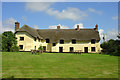
Mooredge Cottages nr Broadclyst, Devon
These fine old thatched cottages, three in a terrace which is L-shaped, are owned by the National Trust. Once part of the nearby Killerton Estate, they were acquired and refurbished by the Trust in 1979. The original cottage is as early as the fifteenth century, with various subsequent add-ons. The cottage to the right is the youngest and is seventeenth century.
Image: © Trevor Durritt
Taken: 26 Jul 2008
0.18 miles
3
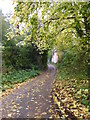
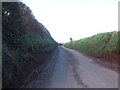
Moor Lane
On the edge of Broadclyst Moor.
Image: © Rod Allday
Taken: 1 Nov 2015
0.19 miles
4
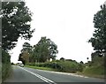
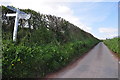
B3181 junction with lane to Mooredge Farm
Beaumont House is also located in this lane to the right.
Image: © John C
Taken: 22 Jul 2019
0.21 miles
5
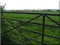
Field near Hay House, Broadclyst in the background
Image: © Rob Purvis
Taken: 25 Apr 2009
0.22 miles
8
East Devon : Burrow Cross
At the crossroads with a signpost pointing the way to Burrow, Budlake, Broadclyst and Ashclyst Forest.
Image: © Lewis Clarke
Taken: 21 Apr 2014
0.25 miles