IMAGES TAKEN NEAR TO
Broadclyst, EXETER, EX5 3JA
Introduction
This page details the photographs taken nearby to EX5 3JA by members of the Geograph project.
The Geograph project started in 2005 with the aim of publishing, organising and preserving representative images for every square kilometre of Great Britain, Ireland and the Isle of Man.

There are currently over 7.5m images from over14,400 individuals and you can help contribute to the project by visiting https://www.geograph.org.uk
Image Map
Images are licensed for reuse under creativecommons.org/licenses/by-sa/2.0
Notes
- Clicking on the map will re-center to the selected point.
- The higher the marker number, the further away the image location is from the centre of the postcode.
Image Listing (18 Images Found)
Images are licensed for reuse under creativecommons.org/licenses/by-sa/2.0
Image
Details
Distance
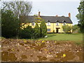
2
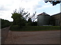
East Devon : Burrow Farm
Looking towards a drive and farmhouse at Burrow Farm.
Image: © Lewis Clarke
Taken: 21 Apr 2014
0.02 miles
4
East Devon : Farm Track
A small lane which joins the lane at Burrow Farm.
Image: © Lewis Clarke
Taken: 21 Apr 2014
0.04 miles
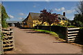
6
East Devon : Farm Track
A track heading towards Carpenter's Cottages.
Image: © Lewis Clarke
Taken: 21 Apr 2014
0.05 miles
7
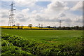
East Devon : Grassy Field
A grassy field with pylons heading through it.
Image: © Lewis Clarke
Taken: 21 Apr 2014
0.09 miles
8
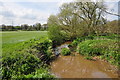
East Devon : River Clyst
The River Clyst heads through the East Devon countryside.
Image: © Lewis Clarke
Taken: 21 Apr 2014
0.09 miles
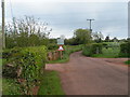
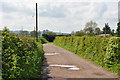
9
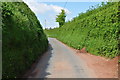
East Devon : Country Lane
A small lane heading through the East Devon countryside.
Image: © Lewis Clarke
Taken: 21 Apr 2014
0.13 miles
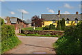
10
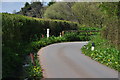
East Devon : Country Lane
A country lane heading through the East Devon countryside.
Image: © Lewis Clarke
Taken: 21 Apr 2014
0.13 miles