IMAGES TAKEN NEAR TO
Broadclyst, EXETER, EX5 3HZ
Introduction
This page details the photographs taken nearby to EX5 3HZ by members of the Geograph project.
The Geograph project started in 2005 with the aim of publishing, organising and preserving representative images for every square kilometre of Great Britain, Ireland and the Isle of Man.

There are currently over 7.5m images from over14,400 individuals and you can help contribute to the project by visiting https://www.geograph.org.uk
Image Map
Images are licensed for reuse under creativecommons.org/licenses/by-sa/2.0
Notes
- Clicking on the map will re-center to the selected point.
- The higher the marker number, the further away the image location is from the centre of the postcode.
Image Listing (37 Images Found)
Images are licensed for reuse under creativecommons.org/licenses/by-sa/2.0
Image
Details
Distance

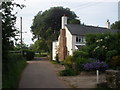
2
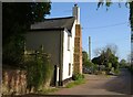
Cottage, Burrow
Hayman's Cottage seen from the northern junction of the triangle of lanes at Burrow. On the right, the lane meets the southern corner of the triangle.
Image: © Derek Harper
Taken: 26 Apr 2006
0.01 miles
5
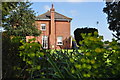
Burrow : Haymans Farmhouse
Looking towards the house by Haymans Farm in East Devon.
Image: © Lewis Clarke
Taken: 21 Apr 2014
0.02 miles
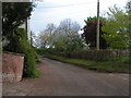
7

Burrow : Country Lane
A lane through the hamlet of Burrow in East Devon.
Image: © Lewis Clarke
Taken: 21 Apr 2014
0.03 miles
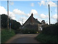
8
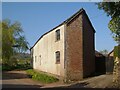
Farm building, Burrow
At Haymans Farm at the north end of the hamlet, and with an angle in the southern wall. A barn conversion, perhaps?
Image: © Derek Harper
Taken: 26 Apr 2006
0.03 miles
9

Old Direction Sign - Signpost by Burrow Road, Burrow
Annulus finial - 3 arms, 2 missing; Devon CC halo by the UC road, in parish of Broad Clyst (East Devon District), Burrow, Burrow Road, opposite Heather Cottage, in hedge at T-junction.
Devon & Dartmoor HER.
HER Number: MDV74088 https://www.heritagegateway.org.uk/Gateway/Results_Single.aspx?uid=MDV74088&resourceID=104
Surveyed
Milestone Society National ID: DV_SX9997A
Image: © Alan Rosevear
Taken: 3 Feb 2013
0.03 miles
10
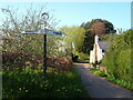
Signpost, Burrow
Perhaps the missing arm said "Rockbeare" (in 2025, the latest Street view is dated 2009 and also shows the arm missing. The lane actually now leads to Cranbrook, which didn't exist until 2012). On the right is a reverse view of Image] with Image] visible.
Image: © Derek Harper
Taken: 26 Apr 2006
0.03 miles