IMAGES TAKEN NEAR TO
Broadclyst, EXETER, EX5 3EY
Introduction
This page details the photographs taken nearby to EX5 3EY by members of the Geograph project.
The Geograph project started in 2005 with the aim of publishing, organising and preserving representative images for every square kilometre of Great Britain, Ireland and the Isle of Man.

There are currently over 7.5m images from over14,400 individuals and you can help contribute to the project by visiting https://www.geograph.org.uk
Image Map
Images are licensed for reuse under creativecommons.org/licenses/by-sa/2.0
Notes
- Clicking on the map will re-center to the selected point.
- The higher the marker number, the further away the image location is from the centre of the postcode.
Image Listing (114 Images Found)
Images are licensed for reuse under creativecommons.org/licenses/by-sa/2.0
Image
Details
Distance

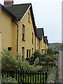
4
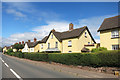
Yellow Houses in Broadclyst
This yellow colour is very popular locally.
Image: © Des Blenkinsopp
Taken: 22 Aug 2016
0.09 miles
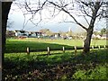
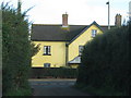
9

Footpath beside Broadclyst Recreation Ground
Image: © David Smith
Taken: 12 Dec 2020
0.13 miles
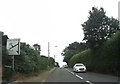
10
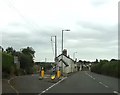
The Old Coach Road goes left off the B3181
The B3181 towards Exeter, south of Broadclyst.
Image: © John C
Taken: 22 Jul 2019
0.13 miles