IMAGES TAKEN NEAR TO
Broadclyst, EXETER, EX5 3DN
Introduction
This page details the photographs taken nearby to EX5 3DN by members of the Geograph project.
The Geograph project started in 2005 with the aim of publishing, organising and preserving representative images for every square kilometre of Great Britain, Ireland and the Isle of Man.

There are currently over 7.5m images from over14,400 individuals and you can help contribute to the project by visiting https://www.geograph.org.uk
Image Map
Images are licensed for reuse under creativecommons.org/licenses/by-sa/2.0
Notes
- Clicking on the map will re-center to the selected point.
- The higher the marker number, the further away the image location is from the centre of the postcode.
Image Listing (5 Images Found)
Images are licensed for reuse under creativecommons.org/licenses/by-sa/2.0
Image
Details
Distance
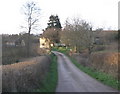
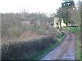
2
The track leading to Higher Comberoy Farm
Image: © Rod Allday
Taken: 2 Mar 2010
0.06 miles
4
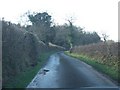
New Road, west of Higher Comberoy Farm
The road skirts the north edge of Ashclyst Forest
Image: © David Smith
Taken: 19 Feb 2011
0.15 miles
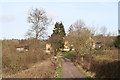
5
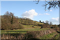
Clyst St Lawrence: near Higher Comberoy Farm
Looking south east. In the valley runs a tributary of the river Clyst
Image: © Martin Bodman
Taken: 10 Mar 2006
0.24 miles