IMAGES TAKEN NEAR TO
Broadclyst, EXETER, EX5 3DE
Introduction
This page details the photographs taken nearby to EX5 3DE by members of the Geograph project.
The Geograph project started in 2005 with the aim of publishing, organising and preserving representative images for every square kilometre of Great Britain, Ireland and the Isle of Man.

There are currently over 7.5m images from over14,400 individuals and you can help contribute to the project by visiting https://www.geograph.org.uk
Image Map
Images are licensed for reuse under creativecommons.org/licenses/by-sa/2.0
Notes
- Clicking on the map will re-center to the selected point.
- The higher the marker number, the further away the image location is from the centre of the postcode.
Image Listing (11 Images Found)
Images are licensed for reuse under creativecommons.org/licenses/by-sa/2.0
Image
Details
Distance


4

Little Barton Farm
Looking past the wooden barn which fronts onto the lane, to the cement mixer, farmhouse and other barns.
Image: © Derek Harper
Taken: 26 Apr 2006
0.07 miles
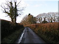
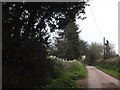
5
Shutter Water Road near Launceston Head
Bare trees and a bank with a few primroses line the road.
Image: © David Smith
Taken: 3 Apr 2012
0.09 miles
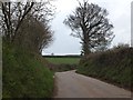
8
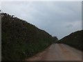
Shutter Water Road
A long straight stretch of country road, with mud on each side and in the centre of the tarmac.
Image: © David Smith
Taken: 3 Apr 2012
0.13 miles

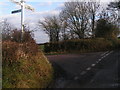
10
Harepathstead Road passing Clyst Gerred Farm
Image: © David Smith
Taken: 3 Apr 2012
0.18 miles