IMAGES TAKEN NEAR TO
Broadclyst, EXETER, EX5 3BZ
Introduction
This page details the photographs taken nearby to EX5 3BZ by members of the Geograph project.
The Geograph project started in 2005 with the aim of publishing, organising and preserving representative images for every square kilometre of Great Britain, Ireland and the Isle of Man.

There are currently over 7.5m images from over14,400 individuals and you can help contribute to the project by visiting https://www.geograph.org.uk
Image Map
Images are licensed for reuse under creativecommons.org/licenses/by-sa/2.0
Notes
- Clicking on the map will re-center to the selected point.
- The higher the marker number, the further away the image location is from the centre of the postcode.
Image Listing (11 Images Found)
Images are licensed for reuse under creativecommons.org/licenses/by-sa/2.0
Image
Details
Distance
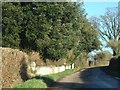
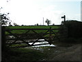
3
Lane past Newlands Farm
Looking right from where Image] was taken.
Image: © Derek Harper
Taken: 26 Apr 2006
0.05 miles
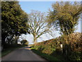
6
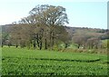
Trees near Newlands Farm
Trees along a field boundary, with Ashclyst Forest on the hills behind.
Image: © Derek Harper
Taken: 26 Apr 2006
0.10 miles
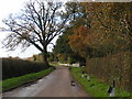
7

Mature trees line the road to Ashclyst
Image: © Roger Cornfoot
Taken: 15 Apr 2010
0.20 miles
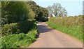
8
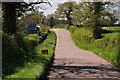
East Devon : Country Road
A road heading through the East Devon countryside.
Image: © Lewis Clarke
Taken: 21 Apr 2014
0.21 miles
9

East Devon : Country Road
Looking along the road which heads through the East Devon countryside.
Image: © Lewis Clarke
Taken: 21 Apr 2014
0.22 miles
10

East Devon : Work Site
Looking towards a work site near the solar farm in East Devon.
Image: © Lewis Clarke
Taken: 21 Apr 2014
0.23 miles