IMAGES TAKEN NEAR TO
Broadclyst, EXETER, EX5 3BW
Introduction
This page details the photographs taken nearby to EX5 3BW by members of the Geograph project.
The Geograph project started in 2005 with the aim of publishing, organising and preserving representative images for every square kilometre of Great Britain, Ireland and the Isle of Man.

There are currently over 7.5m images from over14,400 individuals and you can help contribute to the project by visiting https://www.geograph.org.uk
Image Map
Images are licensed for reuse under creativecommons.org/licenses/by-sa/2.0
Notes
- Clicking on the map will re-center to the selected point.
- The higher the marker number, the further away the image location is from the centre of the postcode.
Image Listing (13 Images Found)
Images are licensed for reuse under creativecommons.org/licenses/by-sa/2.0
Image
Details
Distance
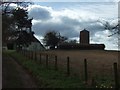
4
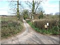
Road passing Broadclyst windmill
The track to Sutherlake Barton Image] joins this road by the nearer telephone pole
Image: © David Smith
Taken: 17 Mar 2011
0.16 miles
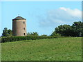
5
Broadclyst windmill and Windmill Cottage
According to Pevsner, the windmill had a short period of use from the late 18th century until 1815
Image: © David Smith
Taken: 17 Mar 2011
0.18 miles

7
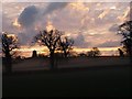
Sunrise over Broadclyst Mill
Taken at 0815hrs 1 Jan 08
Image: © J F North
Taken: 1 Jan 2008
0.20 miles
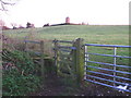
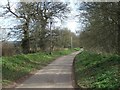
10
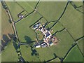
Crabhayes from the air
A view of the farm from a hot air balloon. The lane leads from Loxbrook to Crannaford.
Image: © Derek Harper
Taken: 1 Jul 2009
0.21 miles