IMAGES TAKEN NEAR TO
Broadclyst, EXETER, EX5 3BE
Introduction
This page details the photographs taken nearby to EX5 3BE by members of the Geograph project.
The Geograph project started in 2005 with the aim of publishing, organising and preserving representative images for every square kilometre of Great Britain, Ireland and the Isle of Man.

There are currently over 7.5m images from over14,400 individuals and you can help contribute to the project by visiting https://www.geograph.org.uk
Image Map
Images are licensed for reuse under creativecommons.org/licenses/by-sa/2.0
Notes
- Clicking on the map will re-center to the selected point.
- The higher the marker number, the further away the image location is from the centre of the postcode.
Image Listing (12 Images Found)
Images are licensed for reuse under creativecommons.org/licenses/by-sa/2.0
Image
Details
Distance
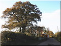
2
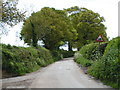
Autumnal trees, near Lower Burrowton
Image: © Roger Cornfoot
Taken: 20 Nov 2009
0.11 miles
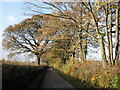
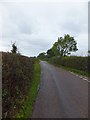
3
East Devon : Country Lane
Looking along a country lane as it heads through East Devon.
Image: © Lewis Clarke
Taken: 4 Aug 2015
0.11 miles
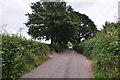
5
Lanes near Broadclyst, with a humpy road ahead
Image: © Rob Purvis
Taken: 3 May 2009
0.16 miles
6
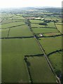
Lane to Broadclyst from the air
The isolated building by the lane is Crannaford Cottage. At this point the lane crosses into Image
Image: © Derek Harper
Taken: 1 Jul 2009
0.17 miles
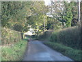
7
Minor road near Lower Burrowton
The road follows a slight ridge north of the valley of the river Clyst
Image: © David Smith
Taken: 18 Sep 2011
0.20 miles
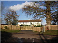
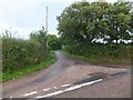
9
Road to Lower Burrowton
There are overhead cables from a large electricity transformer station at Higher Burrowton
Image: © David Smith
Taken: 18 Sep 2011
0.22 miles
10
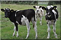
East Devon : Grassy Field & Cattle
A grassy field with some cows grazing.
Image: © Lewis Clarke
Taken: 4 Aug 2015
0.22 miles