IMAGES TAKEN NEAR TO
Broadclyst, EXETER, EX5 3AF
Introduction
This page details the photographs taken nearby to EX5 3AF by members of the Geograph project.
The Geograph project started in 2005 with the aim of publishing, organising and preserving representative images for every square kilometre of Great Britain, Ireland and the Isle of Man.

There are currently over 7.5m images from over14,400 individuals and you can help contribute to the project by visiting https://www.geograph.org.uk
Image Map
Images are licensed for reuse under creativecommons.org/licenses/by-sa/2.0
Notes
- Clicking on the map will re-center to the selected point.
- The higher the marker number, the further away the image location is from the centre of the postcode.
Image Listing (10 Images Found)
Images are licensed for reuse under creativecommons.org/licenses/by-sa/2.0
Image
Details
Distance
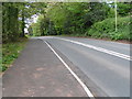
1
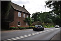
East Devon : The B3181
The road passes a house known as Rosewood.
Image: © Lewis Clarke
Taken: 4 Aug 2015
0.00 miles
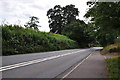
2
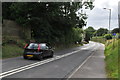
East Devon : The B3181
Looking along the B3181 as it heads into Exeter.
Image: © Lewis Clarke
Taken: 4 Aug 2015
0.01 miles
4
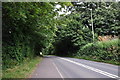
East Devon : The B3181
Looking along the B3181 as it heads towards Broadclyst.
Image: © Lewis Clarke
Taken: 4 Aug 2015
0.04 miles
5
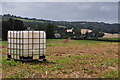
East Devon : Grassy Field
A grassy field in the East Devon countryside.
Image: © Lewis Clarke
Taken: 4 Aug 2015
0.04 miles
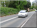
6
East Devon : The B3181
Looking along the B3181 as it heads into Exeter.
Image: © Lewis Clarke
Taken: 4 Aug 2015
0.04 miles
8
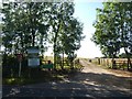
Gateway to Kerswell Barton, near Broadclyst
Image: © David Smith
Taken: 31 Jul 2020
0.19 miles
9
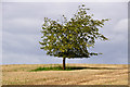
East Devon : Grassy Field & Tree
A grassy field with a tree in it.
Image: © Lewis Clarke
Taken: 4 Aug 2015
0.22 miles
10
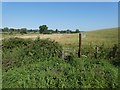
Footpath sign with overgrown vegetation
The path leads to Broadclyst, but seems little used
Image: © David Smith
Taken: 31 Jul 2020
0.23 miles