IMAGES TAKEN NEAR TO
Manley Close, EXETER, EX5 2UG
Introduction
This page details the photographs taken nearby to Manley Close, EX5 2UG by members of the Geograph project.
The Geograph project started in 2005 with the aim of publishing, organising and preserving representative images for every square kilometre of Great Britain, Ireland and the Isle of Man.

There are currently over 7.5m images from over14,400 individuals and you can help contribute to the project by visiting https://www.geograph.org.uk
Image Map
Images are licensed for reuse under creativecommons.org/licenses/by-sa/2.0
Notes
- Clicking on the map will re-center to the selected point.
- The higher the marker number, the further away the image location is from the centre of the postcode.
Image Listing (43 Images Found)
Images are licensed for reuse under creativecommons.org/licenses/by-sa/2.0
Image
Details
Distance
1
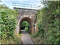
Railway Bridge over a Footpath
A view of the railway bridge over a public footpath in Whimple in Devon. The railway is the main line running between Exeter and Salisbury.
Image: © John P Reeves
Taken: 21 Jun 2022
0.08 miles
2
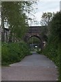
Exeter-Honiton railway crossing a footpath in Whimple
Image: © David Smith
Taken: 6 May 2012
0.08 miles
3
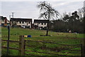
Whimple : Grassy Field
A grassy field in the Whimple outskirts with some horses in view.
Image: © Lewis Clarke
Taken: 5 Apr 2015
0.09 miles
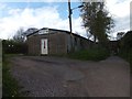
5

Footpath between Houses
A public footpath between residential houses in Whimple in Devon. The access drive to Forge Cottage is on the left.
Image: © John P Reeves
Taken: 21 Jun 2022
0.09 miles
6

Park Cottages, Whimple
This attractive group of cottages is on "The Green", a lane at the western edge of the village.
Image: © Derek Harper
Taken: 1 Jun 2006
0.10 miles
7

Slewton Crescent
A modern development of houses in Whimple
Image: © David Smith
Taken: 18 Sep 2011
0.10 miles
8

Whimple from the air
A rather distant view of Whimple along the railway line seen in Image In the distance is Honiton.
Image: © Derek Harper
Taken: 1 Jul 2009
0.10 miles
9

When was it built?
White House farm just outside the village.
Built in ......
Image: © Anthony Vosper
Taken: 25 Jan 2015
0.10 miles
10
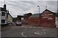
Whimple; Road Junction
A road junction in the town of Whimple with some painted words for St Annes Well Brewery on the wall.
Image: © Lewis Clarke
Taken: 5 Apr 2015
0.11 miles