IMAGES TAKEN NEAR TO
Whimple, EXETER, EX5 2QS
Introduction
This page details the photographs taken nearby to EX5 2QS by members of the Geograph project.
The Geograph project started in 2005 with the aim of publishing, organising and preserving representative images for every square kilometre of Great Britain, Ireland and the Isle of Man.

There are currently over 7.5m images from over14,400 individuals and you can help contribute to the project by visiting https://www.geograph.org.uk
Image Map
Images are licensed for reuse under creativecommons.org/licenses/by-sa/2.0
Notes
- Clicking on the map will re-center to the selected point.
- The higher the marker number, the further away the image location is from the centre of the postcode.
Image Listing (17 Images Found)
Images are licensed for reuse under creativecommons.org/licenses/by-sa/2.0
Image
Details
Distance
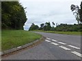
2
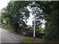
Whimple Wood Cross
The lane ahead leads to Larkbeare. The turning on the left runs to Whimple
Image: © Martin Bodman
Taken: 20 May 2018
0.02 miles
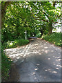
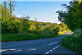
4

Lane to Larkbeare
Running along a ridge, with views to the west, Stitchwort, Campion and Bluebells visible in the hedgebank
Image: © Martin Bodman
Taken: 20 May 2018
0.06 miles

6
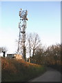
Communications mast, near Whimple Wood Cross
Image: © Roger Cornfoot
Taken: 15 Apr 2010
0.11 miles


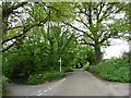
10
East Devon : Country Road
A road heading through East Devon.
Image: © Lewis Clarke
Taken: 13 May 2018
0.14 miles