IMAGES TAKEN NEAR TO
Whimple, EXETER, EX5 2PP
Introduction
This page details the photographs taken nearby to EX5 2PP by members of the Geograph project.
The Geograph project started in 2005 with the aim of publishing, organising and preserving representative images for every square kilometre of Great Britain, Ireland and the Isle of Man.

There are currently over 7.5m images from over14,400 individuals and you can help contribute to the project by visiting https://www.geograph.org.uk
Image Map
Images are licensed for reuse under creativecommons.org/licenses/by-sa/2.0
Notes
- Clicking on the map will re-center to the selected point.
- The higher the marker number, the further away the image location is from the centre of the postcode.
Image Listing (11 Images Found)
Images are licensed for reuse under creativecommons.org/licenses/by-sa/2.0
Image
Details
Distance

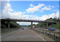
3
A30 advance direction sign for Daisymount
The bridge in the distance is on a minor road north-east of Allercombe
Image: © David Smith
Taken: 3 Feb 2011
0.21 miles
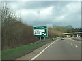
4

Warning sign for Daisymount interchange A30 east
Image: © John Firth
Taken: 14 Jun 2014
0.21 miles
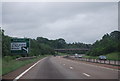

7

Rain on the A30
Looking the other way from the same overbridge as Image on the same foul morning. The dual carriageway quickly crosses into Image
Image: © Derek Harper
Taken: 7 Mar 2006
0.23 miles