IMAGES TAKEN NEAR TO
Whimple, EXETER, EX5 2PF
Introduction
This page details the photographs taken nearby to EX5 2PF by members of the Geograph project.
The Geograph project started in 2005 with the aim of publishing, organising and preserving representative images for every square kilometre of Great Britain, Ireland and the Isle of Man.

There are currently over 7.5m images from over14,400 individuals and you can help contribute to the project by visiting https://www.geograph.org.uk
Image Map
Images are licensed for reuse under creativecommons.org/licenses/by-sa/2.0
Notes
- Clicking on the map will re-center to the selected point.
- The higher the marker number, the further away the image location is from the centre of the postcode.
Image Listing (8 Images Found)
Images are licensed for reuse under creativecommons.org/licenses/by-sa/2.0
Image
Details
Distance
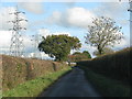
1
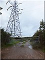
Pylon beside Saundercroft Road
The gate provides access to farm tracks on Saundercroft Farm
Image: © David Smith
Taken: 18 Sep 2011
0.04 miles
3
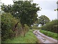
Saundercroft Road
Cables of the National Grid are overhead
Image: © David Smith
Taken: 18 Sep 2011
0.10 miles
4
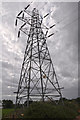
East Devon : Electricity Pylon
An electricity pylon carries power through the countryside.
Image: © Lewis Clarke
Taken: 4 Aug 2015
0.12 miles
6
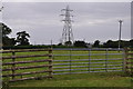
East Devon : Grassy Field & Gate
A gate providing entry into a grassy field.
Image: © Lewis Clarke
Taken: 4 Aug 2015
0.13 miles
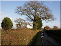
7
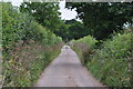
East Devon : Saundercroft Road
A small road heading through the East Devon countryside.
Image: © Lewis Clarke
Taken: 4 Aug 2015
0.17 miles
8
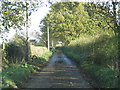
Grass growing in the middle of this narrow road
Image: © Sarah Charlesworth
Taken: 16 Nov 2010
0.24 miles