IMAGES TAKEN NEAR TO
Whimple, EXETER, EX5 2PE
Introduction
This page details the photographs taken nearby to EX5 2PE by members of the Geograph project.
The Geograph project started in 2005 with the aim of publishing, organising and preserving representative images for every square kilometre of Great Britain, Ireland and the Isle of Man.

There are currently over 7.5m images from over14,400 individuals and you can help contribute to the project by visiting https://www.geograph.org.uk
Image Map
Images are licensed for reuse under creativecommons.org/licenses/by-sa/2.0
Notes
- Clicking on the map will re-center to the selected point.
- The higher the marker number, the further away the image location is from the centre of the postcode.
Image Listing (31 Images Found)
Images are licensed for reuse under creativecommons.org/licenses/by-sa/2.0
Image
Details
Distance
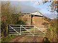
3
Barn at Tub Corner
Another view of this farm, with more content, is Image
Image: © David Smith
Taken: 18 Sep 2011
0.12 miles

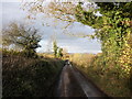
6
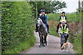
East Devon : Saundercroft Road
Looking along Saundercroft Road with some people enjoying a horse ride.
Image: © Lewis Clarke
Taken: 4 Aug 2015
0.14 miles
7
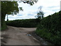
Junction for Rockbeare or Clyst St Lawrence
Image: © Rob Purvis
Taken: 3 May 2009
0.15 miles
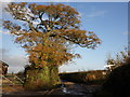
8
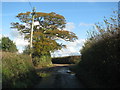
Autumn colour on the tree by the crossroads
Image: © Sarah Charlesworth
Taken: 16 Nov 2010
0.15 miles
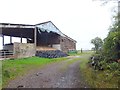
9
Tub Corner
The road south leads across the Clyst Valley
Image: © David Smith
Taken: 18 Sep 2011
0.15 miles
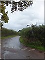
10
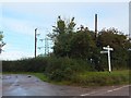
Wards Cross
The pylon carries cables connected to the nearby transformer station. The "cross" is a staggered crossroads; this signpost is a junction.
Image: © David Smith
Taken: 18 Sep 2011
0.16 miles