IMAGES TAKEN NEAR TO
Rockbeare, EXETER, EX5 2LS
Introduction
This page details the photographs taken nearby to EX5 2LS by members of the Geograph project.
The Geograph project started in 2005 with the aim of publishing, organising and preserving representative images for every square kilometre of Great Britain, Ireland and the Isle of Man.

There are currently over 7.5m images from over14,400 individuals and you can help contribute to the project by visiting https://www.geograph.org.uk
Image Map
Images are licensed for reuse under creativecommons.org/licenses/by-sa/2.0
Notes
- Clicking on the map will re-center to the selected point.
- The higher the marker number, the further away the image location is from the centre of the postcode.
Image Listing (26 Images Found)
Images are licensed for reuse under creativecommons.org/licenses/by-sa/2.0
Image
Details
Distance


5
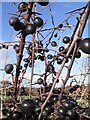
Sloes on A30 embankment, Marsh Green
Sloes and other natural shrubs planted on A30 embankment, Marsh Green
Image: © Robin Pearson
Taken: 24 Nov 2006
0.14 miles
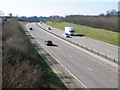
6

East Devon : The A30
A road heading through East Devon.
Image: © Lewis Clarke
Taken: 13 May 2018
0.15 miles
7
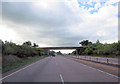
A30 passing under power lines
Gribble Lane bridge in distance
Image: © John Firth
Taken: 24 Oct 2015
0.15 miles