IMAGES TAKEN NEAR TO
Sidmouth Road, EXETER, EX5 2JT
Introduction
This page details the photographs taken nearby to Sidmouth Road, EX5 2JT by members of the Geograph project.
The Geograph project started in 2005 with the aim of publishing, organising and preserving representative images for every square kilometre of Great Britain, Ireland and the Isle of Man.

There are currently over 7.5m images from over14,400 individuals and you can help contribute to the project by visiting https://www.geograph.org.uk
Image Map
Images are licensed for reuse under creativecommons.org/licenses/by-sa/2.0
Notes
- Clicking on the map will re-center to the selected point.
- The higher the marker number, the further away the image location is from the centre of the postcode.
Image Listing (22 Images Found)
Images are licensed for reuse under creativecommons.org/licenses/by-sa/2.0
Image
Details
Distance
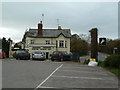
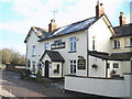
4
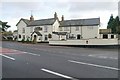
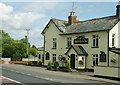
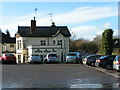
White Horse Inn, Farringdon
The White Horse Inn, Farringdon, Devon, on the A3052 Exeter to Sidmouth road.
Image: © Kevin Hale
Taken: 5 Dec 2005
0.07 miles
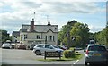
6
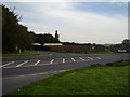
Farringdon Junction
On the A3052 also giving access to the Hill Barton Business park.
Image: © Anthony Vosper
Taken: 7 Oct 2012
0.08 miles
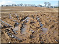
9
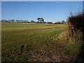
Field at Greendale
The same field taken from the same spot on White Cross Road as Image, but looking very different, with a winter grass crop burgeoning forth. The line of trees marks the course of the A3052.
Image: © Derek Harper
Taken: 4 Jan 2010
0.12 miles
10
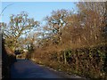
White Cross Road
The lane leading up from Greendale to the A3052 at the inn - http://www.geograph.org.uk/gridref/SY0290?centi=SY024904 - with a narrow belt of trees on the right and oaks scattered along the left-side hedge.
Image: © Derek Harper
Taken: 4 Jan 2010
0.12 miles