IMAGES TAKEN NEAR TO
Withen Lane, EXETER, EX5 2JQ
Introduction
This page details the photographs taken nearby to Withen Lane, EX5 2JQ by members of the Geograph project.
The Geograph project started in 2005 with the aim of publishing, organising and preserving representative images for every square kilometre of Great Britain, Ireland and the Isle of Man.

There are currently over 7.5m images from over14,400 individuals and you can help contribute to the project by visiting https://www.geograph.org.uk
Image Map
Images are licensed for reuse under creativecommons.org/licenses/by-sa/2.0
Notes
- Clicking on the map will re-center to the selected point.
- The higher the marker number, the further away the image location is from the centre of the postcode.
Image Listing (6 Images Found)
Images are licensed for reuse under creativecommons.org/licenses/by-sa/2.0
Image
Details
Distance
1
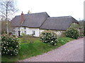
Withen Farm
The listed C16 farmhouse, is described at http://list.english-heritage.org.uk/resultsingle.aspx?uid=1141424&searchtype=mapsearch , and also appears in Image
Image: © Derek Harper
Taken: 29 Mar 2006
0.00 miles
2
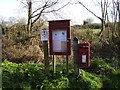
Aylesbeare Parish Council Notice Board
Situated along with a small Post Box near Withens Farm.
Image: © Anthony Vosper
Taken: 27 Jan 2013
0.02 miles
3
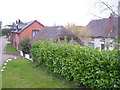
Withen Farm
View in a hamlet near Aylesbeare, looking SW. The listed C16 farmhouse, on the right, is also shown in Image "Withen is a little-modernised farmhouse with much of its long structural history hidden by later plaster" http://list.english-heritage.org.uk/resultsingle.aspx?uid=1141424&searchtype=mapsearch .
Image: © Derek Harper
Taken: 29 Mar 2006
0.03 miles
4
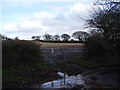
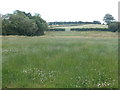
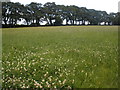
One muddy path
Heavy persistent winter rain has left a good deal of Devon's fields saturated with water.
Image: © Anthony Vosper
Taken: 27 Jan 2013
0.06 miles