IMAGES TAKEN NEAR TO
Farringdon, EXETER, EX5 2JA
Introduction
This page details the photographs taken nearby to EX5 2JA by members of the Geograph project.
The Geograph project started in 2005 with the aim of publishing, organising and preserving representative images for every square kilometre of Great Britain, Ireland and the Isle of Man.

There are currently over 7.5m images from over14,400 individuals and you can help contribute to the project by visiting https://www.geograph.org.uk
Image Map
Images are licensed for reuse under creativecommons.org/licenses/by-sa/2.0
Notes
- Clicking on the map will re-center to the selected point.
- The higher the marker number, the further away the image location is from the centre of the postcode.
Image Listing (18 Images Found)
Images are licensed for reuse under creativecommons.org/licenses/by-sa/2.0
Image
Details
Distance

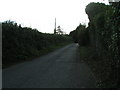
3
B3184 to Sidmouth and public footpath into the field
Image: © Rob Purvis
Taken: 1 Oct 2009
0.07 miles


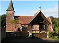


10
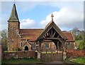
St Petrock's church, Farringdon
Another view of Image to include the whole of the lych gate (1888 - http://www.historicengland.org.uk/listing/the-list/list-entry/1141400 ). The church is grade II* listed: it "has an attractive setting and as a Victorian Gothic church is very successful" http://www.historicengland.org.uk/listing/the-list/list-entry/1328759 (a very thorough description).
Image: © Derek Harper
Taken: 27 Mar 2006
0.22 miles