IMAGES TAKEN NEAR TO
Marsh Green, EXETER, EX5 2HE
Introduction
This page details the photographs taken nearby to EX5 2HE by members of the Geograph project.
The Geograph project started in 2005 with the aim of publishing, organising and preserving representative images for every square kilometre of Great Britain, Ireland and the Isle of Man.

There are currently over 7.5m images from over14,400 individuals and you can help contribute to the project by visiting https://www.geograph.org.uk
Image Map
Images are licensed for reuse under creativecommons.org/licenses/by-sa/2.0
Notes
- Clicking on the map will re-center to the selected point.
- The higher the marker number, the further away the image location is from the centre of the postcode.
Image Listing (10 Images Found)
Images are licensed for reuse under creativecommons.org/licenses/by-sa/2.0
Image
Details
Distance
1

Higher and Lower Upcott
As seen from above the A30 on the way to Exeter Airport.
Image: © M J Richardson
Taken: 11 Jan 2015
0.04 miles
2
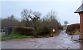
Lane junction, Pithead
A total of five lanes meet here by the village hall shown in Image Will it never stop raining?
Image: © Derek Harper
Taken: 7 Mar 2006
0.09 miles
3
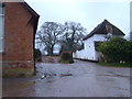
Pithead, near Rockbeare
Scarcely even a hamlet, Pithead consists of a few houses, including this cottage and, on the left, an Independent chapel dating from 1840 and now used as a village hall. Seen looking SE. 7:42 am
Image: © Derek Harper
Taken: 7 Mar 2006
0.12 miles
4

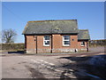
Pitt Head
This "cottage and former outbuildings" http://list.english-heritage.org.uk/resultsingle.aspx?uid=1141385&searchtype=mapsearch can be seen in Image Beside it runs Palmers Lane.
Image: © Derek Harper
Taken: 7 Mar 2006
0.12 miles


9
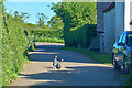
East Devon : Palmer's Lane
Looking along Palmer's Lane in East Devon.
Image: © Lewis Clarke
Taken: 13 May 2018
0.24 miles
10
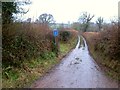
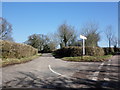
Turkey Lane
Turned thus by the A30 dual carriageway built in 1999, which truncated this road, formerly a link between Marsh Green and Strete Ralegh. Seen from its junction with the lane to Allercombe. The rain continues.
Image: © Derek Harper
Taken: 7 Mar 2006
0.24 miles