IMAGES TAKEN NEAR TO
Anning Road, EXETER, EX5 2GD
Introduction
This page details the photographs taken nearby to Anning Road, EX5 2GD by members of the Geograph project.
The Geograph project started in 2005 with the aim of publishing, organising and preserving representative images for every square kilometre of Great Britain, Ireland and the Isle of Man.

There are currently over 7.5m images from over14,400 individuals and you can help contribute to the project by visiting https://www.geograph.org.uk
Image Map
Images are licensed for reuse under creativecommons.org/licenses/by-sa/2.0
Notes
- Clicking on the map will re-center to the selected point.
- The higher the marker number, the further away the image location is from the centre of the postcode.
Image Listing (66 Images Found)
Images are licensed for reuse under creativecommons.org/licenses/by-sa/2.0
Image
Details
Distance
1

New offices, Anning Road, Exeter Science Park
The facade incorporates some white bricks to create a mottled effect
Image: © David Smith
Taken: 26 May 2020
0.01 miles
2
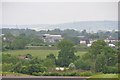
East Devon : Countryside Scenery
Looking across the countryside on the outskirts of Exeter.
Image: © Lewis Clarke
Taken: 30 May 2013
0.02 miles
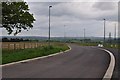
3
East Devon : Park Drive North
Looking along Park Drive North from Blackhorse Lane.
Image: © Lewis Clarke
Taken: 30 May 2013
0.02 miles
4
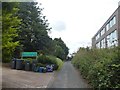
Sign for boarding kennels, near Pinhoe
The building housing the kennels first appears on maps from the 1960s; in the 2000s the area is being developed for housing estates and a science park (outpost of Exeter University opposite)
Image: © David Smith
Taken: 24 Jul 2020
0.02 miles
5
East Devon : Park Drive North
Park Drive North heading from here towards Tithebam Lane.
Image: © Lewis Clarke
Taken: 30 May 2013
0.02 miles
6
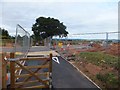
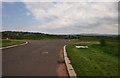
Construction of a road on Exeter Science Park
The cycle path has been opened, the road is yet to be completed. Nonetheless, the road markings are present! One wonders why the "Give Way" paint is on the right side of the cycle path.
Image: © David Smith
Taken: 13 Aug 2011
0.04 miles
7
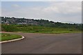
East Devon : Park Drive South
Looking along Park Drive South which is part of the new Exeter Science Park.
Image: © Lewis Clarke
Taken: 30 May 2013
0.04 miles
8
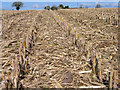
Grain maize stubble
On sandy soils of the Cuckney Series, typical brown sands, the residue of maize harvested for grain, rather than for forage, affords protection from rain impact on the surface on these easily eroded soils. The view is from a 4° slope, NNW towards Sunnymead on Blackhorse Lane.
Image: © Rodney Burton
Taken: 4 Mar 2008
0.05 miles
9
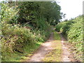
Lane now just a footpath near Redhayes
This used to continue towards Exeter but was cut off by the building of the M5.
Image: © Rob Purvis
Taken: 14 Sep 2008
0.06 miles
10
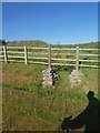
Drainage ditch by Anning Road, Exeter Science Park
Carefully excavated and marked with these two plinths supporting the fence
Image: © David Smith
Taken: 26 May 2020
0.06 miles