IMAGES TAKEN NEAR TO
Blackhorse, EXETER, EX5 2FT
Introduction
This page details the photographs taken nearby to EX5 2FT by members of the Geograph project.
The Geograph project started in 2005 with the aim of publishing, organising and preserving representative images for every square kilometre of Great Britain, Ireland and the Isle of Man.

There are currently over 7.5m images from over14,400 individuals and you can help contribute to the project by visiting https://www.geograph.org.uk
Image Map
Images are licensed for reuse under creativecommons.org/licenses/by-sa/2.0
Notes
- Clicking on the map will re-center to the selected point.
- The higher the marker number, the further away the image location is from the centre of the postcode.
Image Listing (59 Images Found)
Images are licensed for reuse under creativecommons.org/licenses/by-sa/2.0
Image
Details
Distance
1
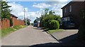
Endsleigh Crescent, Blackhorse
A residential cul-de-sac
Image: © David Smith
Taken: 11 Jul 2020
0.01 miles
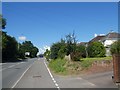
5
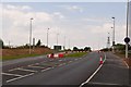
East Devon : Honiton Road
The old Honiton Road heading towards the new Honiton Road.
Image: © Lewis Clarke
Taken: 30 May 2013
0.08 miles
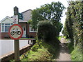
6
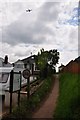
Blackhorse : Small Footpath
A footpath heading from Blackhorse Lane towards Endsleigh Crescent.
Image: © Lewis Clarke
Taken: 30 May 2013
0.09 miles
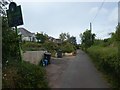
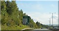
8
Blackhorse : Blackhorse Lane
Blackhorse Lane heading through the small hamlet of Blackhorse.
Image: © Lewis Clarke
Taken: 30 May 2013
0.10 miles
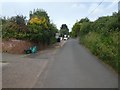
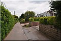
10

Blackhorse : Blackhorse Lane
Blackhorse Lane heading between Exeter and Clyst Honiton.
Image: © Lewis Clarke
Taken: 30 May 2013
0.10 miles