IMAGES TAKEN NEAR TO
Farringdon, EXETER, EX5 2FA
Introduction
This page details the photographs taken nearby to EX5 2FA by members of the Geograph project.
The Geograph project started in 2005 with the aim of publishing, organising and preserving representative images for every square kilometre of Great Britain, Ireland and the Isle of Man.

There are currently over 7.5m images from over14,400 individuals and you can help contribute to the project by visiting https://www.geograph.org.uk
Image Map
Images are licensed for reuse under creativecommons.org/licenses/by-sa/2.0
Notes
- Clicking on the map will re-center to the selected point.
- The higher the marker number, the further away the image location is from the centre of the postcode.
Image Listing (5 Images Found)
Images are licensed for reuse under creativecommons.org/licenses/by-sa/2.0
Image
Details
Distance
2
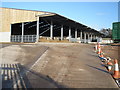
New farm building near Denbow Farm
I think this is the third large barn to be built along this stretch of lane in recent years.
Image: © Derek Harper
Taken: 14 Aug 2016
0.22 miles
3
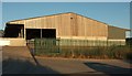
Modern farm buildings at Denbow Farm
These buildings are of recent construction (Image shows them while they were being built)
Image: © David Smith
Taken: 1 Aug 2011
0.22 miles
4
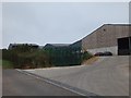
Scene near Denbow Farm
The east Devon countryside west of Farringdon. View looking south.
Image: © Derek Harper
Taken: 27 Mar 2006
0.24 miles
5
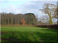
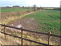
Towards Farringdon Wood
A view from a gate by Willow Farm, with the wood two fields away. But here's something I can't explain - there's clearly a building, apparently a house, on the right, which doesn't seem to appear on maps or satellite images.
Image: © Derek Harper
Taken: 27 Mar 2006
0.24 miles